A walk in the footsteps of the "old smugglers".
- Strecke12,23 km
- Dauer5:50 h
- Aufstieg1069 Hm
- Abstieg1069 Hm
- Schwierigkeitmittel
Höhenprofil
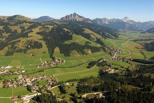
We are already at the top station of the Wannenjochbahn in Schattwald. The hiking trail is well signposted and already a bit worn out. The slope is moderately steep and not very difficult to walk on. We quickly gain height and have quickly left the last mountain pines under us. Relatively late we see the summit cross, so that the summit is reached after only a few minutes. At a sea level of 1852m we have an impressive view, almost up to the Bodensee. The path continues now partly on the ridge. Moderately up and down, but keeping the height and still with an impressive view. After almost an hour we reach the Iseler.
After a rest we start the descent, over the grass-covered slope to the saddle between Wannenjoch and Bscheißer. When we look at the Wannenjoch we see a straight path. This is the border between Austria and Germany.
On the way back we pass the Zipfelsalpe and finally to the Stuibensennalpe. From there we walk along the Stuibenbach stream back to Schattwald.
On the back of the Wannenjoch, the name comes from the tub under the yoke, the border to Germany runs. Often this mountain is marked in maps as Kühgundkopf with Kühgund ridge.
We meet at the top station of the Wannenjochbahn in Schattwald. It is still a bit chilly in the early morning hours, but the sunbeams are already warming us up here. The view over the whole Tannheimer Tal and into the Allgäu is already fantastic, how could this view be only at the summit? The newly laid out "smugglers' path", an easy hike for the whole family, starts right at the Jochstadel, the refreshment point at the mountain station. The self-built Kinderland also deserves a closer look. Some of us would not have expected such a play landscape at this altitude.
The slope is moderately steep and easy to walk on. More and more we gain height, the last leg pines, popularly called "Latschen", we have left behind us long ago. Barren vegetation covers the slope, but these plants are typical for this region, and some of them are new to us. Every now and then the bare rock lies in front of us - a clear sign of the departure of a ground snow avalanche. With a little attention you can also see some animals, even adders can be found here. Relatively late we see the summit cross, so we reach the summit after a few minutes. At an altitude of 1852m we have an impressive view far into the Allgäu, beginning with Oberjoch, and with good visibility almost to Lake Constance. The entry in the summit book is simply part of it, as well as a snack on the summit. After a short rest we continue. Mountain jackdaws accompany us on our way, which partly runs on the ridge. Moderately up and down, but keeping the height, we reach the Iseler after not even one hour. Now we allow ourselves an extensive rest. The sunbeams invite us to take a little rest.
The descent over the grass-covered slope leads us down quickly. We have already reached the vegetation border again and now and then we even hear marmots whistling.
At a fork in the path a signpost points to the Zipfelsalpe. After a short arrangement of the group we decide to walk towards the Zipfelsalpe. On the saddle between Wannenjoch and Bscheißer we can still see the foundation walls of Oberer Stuiben. There used to be a hut here, but it was no longer in use and is therefore dilapidated. When we look at the Wannenjoch we see a straight path. This is the border between Austria and Germany.
Arrived at the Zipfelsalpe, we have a short break before we continue towards Stuiben Sennalpe. From there we decide to walk along the Stuibenbach towards the valley station. Saying goodbye at the parking lot is almost associated with a bit of melancholy, but still makes you want to see each other again.
Anfahrt
On the motorway A7 at the exit "Oy-Mittelberg" on the B310 towards Wertach and to Oberjoch. There follow the signs "Tannheimer Tal" B199, exit Schattwald, direction Wannenjoch Bergbahn.From the Tyrolean side via Reutte on the B198 towards Lechtal to Weißenbach, over the Gaichtpass along the B199 to the Schattwald exit, direction Wannenjoch Bergbahn.
Parken
Wannenjochbahn in SchattwaldÖffentliche Verkehrsmittel
By train to Sonthofen, Pfronten/Ried or Reutte, then by bus to Schattwald.
It should be noted that in mountaineering there is an increased risk of accidents and injuries. Despite careful route planning, a basic risk always remains. Tour preparation through endurance sports, appropriate technical training and further education as well as personal prudence reduces the danger of accidents and risks. However, please never forget that the weather in the mountains can change very quickly. Stay on the marked hiking trails.
The personal mountaineering equipment must be safe and serviceable and meet the relevant technical standards. Every hiker is recommended to obtain information about the planned tours from specialist alpine literature or on site.
Ähnliche Touren
- Wandertour
"Gutes vom Dorf" - Culinary hike through Ofterschwang
Tradition, untouched landscape and a lot of regional delicacies - that is what distinguishes Ofterschwang.
mehr dazuDistanz 11,8 km Dauer 3:30 h Aufstieg 309 m Schwierigkeit mittel - Wandertour
"Wiesengänger"-Trail
© Allgäu GmbH
The "Wasserläufer"-Route takes you through a beautiful hilly landscape on 463 km.
mehr dazuDistanz 424,8 km Dauer 107:30 h Aufstieg 5.300 m Schwierigkeit mittel - Wandertour
Alpine Meadows - hiking tour from Ofterschwang
Varied and cozy through forests and over meadows. Great views, varied nature and small playgrounds along the way with refreshments.
mehr dazuDistanz 8,3 km Dauer 3:00 h Aufstieg 427 m Schwierigkeit mittel - Wandertour
Border guard trail Oberreute/Allgaeu
Cross-border experience path for the whole family.
mehr dazuDistanz 9,1 km Dauer 2:30 h Aufstieg 173 m Schwierigkeit mittel - Wandertour
Castle ruin Falkenstein
Castle ruin Falkenstein
mehr dazuDistanz 7,8 km Dauer 3:00 h Aufstieg 530 m Schwierigkeit mittel - Wandertour
Family hike across Ochsenkopf via Riedberger Horn – climbing for kids
Family hike across Ochsenkopf via Riedberger Horn – climbing for kids
mehr dazuDistanz 12,9 km Dauer 4:23 h Aufstieg 591 m Schwierigkeit mittel - Wandertour
Hiking on the ridgeway ('Hoehenweg') from Scheidegg to the mountain Pfaender - the classic
The wonderful hiking tour leads you from Scheidegg through the German-Austrian alpine upland to the mountain Pfaender heighted 1064 meters. There you will be rewarded with an impressive panoramic view.
mehr dazuDistanz 10,9 km Dauer 3:30 h Aufstieg 415 m Schwierigkeit mittel - Wandertour
Hiking trail from Ofterschwang via Ofterschwanger Horn and Sigiswang
Scenic mountain tour to the Ofterschwanger Horn (peak).
mehr dazuDistanz 11,3 km Dauer 4:30 h Aufstieg 678 m Schwierigkeit mittel - Wandertour
Hochwiesweg Hike
A gorgeous little loop with beautiful views.
(pram friendly tour)
mehr dazuDistanz 3,9 km Dauer 1:00 h Aufstieg 120 m Schwierigkeit mittel - Wandertour
Hörner Panorama Tour - lovely mountain hike from Bolsterlang or Ofterschwang
This fantastic tour can start either in Bolsterlang or Ofterschwang and takes you over the popular Hörner Panorama Tour along the Weiherkopf, Rangiswanger Horn, Sigiswanger Horn and Ofterschwanger Horn.
mehr dazuDistanz 16,3 km Dauer 7:45 h Aufstieg 1.017 m Schwierigkeit mittel


Die Inhalte dieser Seite werden in Kooperation mit Outdooractive bereitgestellt.