This fantastic tour can start either in Bolsterlang or Ofterschwang and takes you over the popular Hörner Panorama Tour along the Weiherkopf, Rangiswanger Horn, Sigiswanger Horn and Ofterschwanger Horn.
- Strecke16,34 km
- Dauer7:45 h
- Aufstieg1017 Hm
- Abstieg1040 Hm
- Schwierigkeitmittel
Höhenprofil
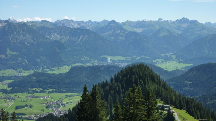
The unquestioned hiking classic in the Hörnerdörfer is undoubtedly the Hörner Panorama Tour. With only slight ascents and descents, this hiking trail is also suitable for families with little hikers.
The unquestioned classic in the Hörnerdörfer is undoubtedly the Hörner Panorama Tour. With only slight ascents and descents, this hiking trail is also suitable for families with little hikers. The tour can be started either in Bolsterlang, or in Ofterschwang. From the mountain station of the Hörnerbahn (1550), which can be reached by car or on foot, the steepest passage leads to the highest point of the tour - the Weiherkopf (1665). If you do not want to take the steep ascent, you can also take the opportunity to go across below the peak.
Following the panoramic trail, you can now bypass or climb the following peaks - Rangiswanger Horn (1612) - Sigiswanger Horn (1527) - Ofterschwanger Horn (1408). Best summits for a fabulous all-round view in the Allgäu Alps are the Weiherkopf the Rangiswanger Horn and Ofterschwanger Horn.
In Ofterschwang, you can take the cable car Weltcup-Express back into the valley, or take the panoramic trail downhill past Alpe Eck.
The return path from Ofterschwang follows via Sigiswang and Kierwang back to the starting point. Alternatively, you can also take the bus back, please check the departure times.
Anfahrt
The access to Ofterschwang is via the B19, with exit Sigishofen at Sonthofen or via Tiefenberg. Or carry on to Fischen and turn right in direction of Riedbergpass and again right to BolsterlangParken
Free parking at the Weltcup-Express base station in Ofterschwang or the Hörnerbahn in Bolsetrlang.Öffentliche Verkehrsmittel
From the Sonthofen train station by bus to Ofterschwang or Bolsterlang (bus route Sonthofen - Ofterschwang - Bolsterlang) or via Fischen (via Bolsterlang)You are in the Nature Park Nagelfluhkette. A Nature Park is a protected landscape created by long-term use and cultivation. This valuable cultural landscape is to be preserved in its present form, but at the same time also to be used.
Please note the following recommendations:
- Please do not make noise.
- Please do not go off the road.
- Please do not make an open fire.
- Please only camp on marked areas.
- Please do not resettle plants or animals.
- Please do not pick plants and flowers.
- Please do not collect mushrooms.
- Please do not collect stones or minerals.
- Please do not feed animals.
- Please do not leave any rubbish.
- Please dispose of dog droppings in public dog kennels or at home
The right equipment for your tour consists of proper hiking boots and clothing appropriate to the weather. This tour takes you along a partially exposed ridge. Take sun cream and water along. Note that you are in the mountains and weather changes can be expected at any time.
Ähnliche Touren
- Wandertour
"Gutes vom Dorf" - Culinary hike through Ofterschwang
Tradition, untouched landscape and a lot of regional delicacies - that is what distinguishes Ofterschwang.
mehr dazuDistanz 11,8 km Dauer 3:30 h Aufstieg 309 m Schwierigkeit mittel - Wandertour
"Wiesengänger"-Trail
© Allgäu GmbH
The "Wasserläufer"-Route takes you through a beautiful hilly landscape on 463 km.
mehr dazuDistanz 424,8 km Dauer 107:30 h Aufstieg 5.300 m Schwierigkeit mittel - Wandertour
Alpine Meadows - hiking tour from Ofterschwang
Varied and cozy through forests and over meadows. Great views, varied nature and small playgrounds along the way with refreshments.
mehr dazuDistanz 8,3 km Dauer 3:00 h Aufstieg 427 m Schwierigkeit mittel - Wandertour
Border guard trail Oberreute/Allgaeu
Cross-border experience path for the whole family.
mehr dazuDistanz 9,1 km Dauer 2:30 h Aufstieg 173 m Schwierigkeit mittel - Wandertour
Castle ruin Falkenstein
Castle ruin Falkenstein
mehr dazuDistanz 7,8 km Dauer 3:00 h Aufstieg 530 m Schwierigkeit mittel - Wandertour
Family hike across Ochsenkopf via Riedberger Horn – climbing for kids
Family hike across Ochsenkopf via Riedberger Horn – climbing for kids
mehr dazuDistanz 12,9 km Dauer 4:23 h Aufstieg 591 m Schwierigkeit mittel - Wandertour
Hiking on the ridgeway ('Hoehenweg') from Scheidegg to the mountain Pfaender - the classic
The wonderful hiking tour leads you from Scheidegg through the German-Austrian alpine upland to the mountain Pfaender heighted 1064 meters. There you will be rewarded with an impressive panoramic view.
mehr dazuDistanz 10,9 km Dauer 3:30 h Aufstieg 415 m Schwierigkeit mittel - Wandertour
Hiking trail from Ofterschwang via Ofterschwanger Horn and Sigiswang
Scenic mountain tour to the Ofterschwanger Horn (peak).
mehr dazuDistanz 11,3 km Dauer 4:30 h Aufstieg 678 m Schwierigkeit mittel - Wandertour
Hochwiesweg Hike
A gorgeous little loop with beautiful views.
(pram friendly tour)
mehr dazuDistanz 3,9 km Dauer 1:00 h Aufstieg 120 m Schwierigkeit mittel - Wandertour
Kapellenwanderung in Stiefenhofen
Kapellenwanderung in Stiefenhofen
mehr dazuDistanz 14,0 km Dauer 4:00 h Aufstieg 326 m Schwierigkeit mittel


Die Inhalte dieser Seite werden in Kooperation mit Outdooractive bereitgestellt.