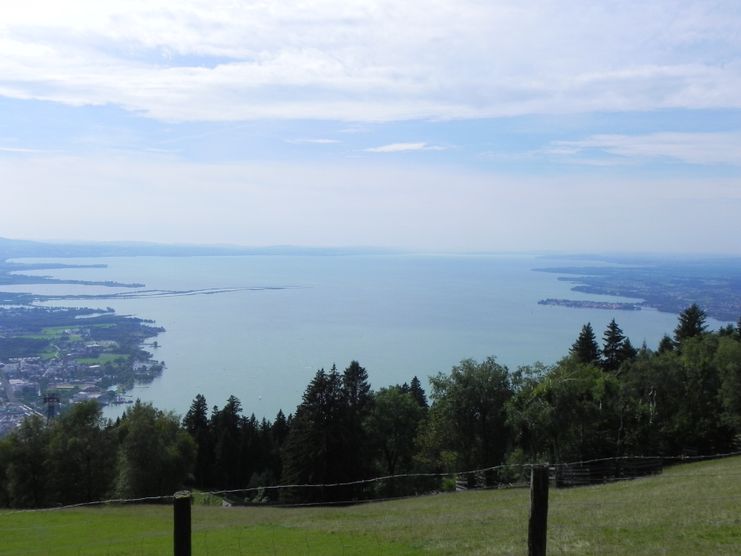
The wonderful hiking tour leads you from Scheidegg through the German-Austrian alpine upland to the mountain Pfaender heighted 1064 meters. There you will be rewarded with an impressive panoramic view.
- Strecke10,95 km
- Dauer3:30 h
- Aufstieg415 Hm
- Abstieg214 Hm
- Schwierigkeitmittel
Höhenprofil
On the hiking tour from Scheidegg to the Pfaender we can gaze at the region from a height of 40 meters on the skywalk allgaeu. On the Pfaender we can observe birds of prey and look towards Switzerland, Liechtenstein, Austria and Germany. Finally, we float down from the mountaintop to Bregenz in a nacelle.
The day trip to the Pfaender starts at the spa house in Scheidegg. There we follow the official signage to Oberschwenden. Already at the beginning of the tour, we cover the first heights. At the parking lot of the Prinz-Luitpold children'S hospital, we leave the forest and pass the village Oberschwenden. We follow the trail uphill to the skywalk allgaeu. There we can enjoy the beautiful view of the surrounding landscape. From the panoramic trail in the trees we hike downhill to Moeggers bearing left. On the way to the village we cross the boarder. There's a short ascent shortly before we reach the village Moeggers in Vorarlberg. There we get to the chapel of St. Ulrich which is a beautiful viewpoint of Lake Constance because of its elevated position. In Moeggers we bear left and hike uphill covering a parking lot until we reach the mountain Hochberg. Starting there, we hike downhill on a paved road. At the next crossroads we choose the gravel path towards the Pfänder. We leave the forest and reach a steep pathway. We stay on the ridgeway and hike pass two gates until we get own a downhill way to Moos. We then take a frequented road towards the Pfaender which can be recognised from a distance because of its remarkable red and white radio tower.We can follow the well signposted way to the mountain station of the Pfaenderbahn whence a narrow path steeply uphill leads us to the top of the local mountain of Bregenz. On the Pfaender there are some inns, a playground for families, a wildlife park and a fascinating eagle show. The best thing about this versatile range is the wonderful view of the alps and the whole area of Lake Constance. The Pfaenderbahn takes us from the mountain to Bregenz on lake level. There we can drive by ferry, bus or train back to our starting point.
The day trip can also lead from the Pfaender to Scheidegg.
The day trip can also lead from the Pfaender to Scheidegg.
Sturdy shoes and clothing suitable for the weather.
Ähnliche Touren
- Wandertour
"Gutes vom Dorf" - Culinary hike through Ofterschwang
Tradition, untouched landscape and a lot of regional delicacies - that is what distinguishes Ofterschwang.
mehr dazuDistanz 11,8 km Dauer 3:30 h Aufstieg 309 m Schwierigkeit mittel - Wandertour
"Wiesengänger"-Trail
© Allgäu GmbH
The "Wasserläufer"-Route takes you through a beautiful hilly landscape on 463 km.
mehr dazuDistanz 424,8 km Dauer 107:30 h Aufstieg 5.300 m Schwierigkeit mittel - Wandertour
Alpine Meadows - hiking tour from Ofterschwang
Varied and cozy through forests and over meadows. Great views, varied nature and small playgrounds along the way with refreshments.
mehr dazuDistanz 8,3 km Dauer 3:00 h Aufstieg 427 m Schwierigkeit mittel - Wandertour
Border guard trail Oberreute/Allgaeu
Cross-border experience path for the whole family.
mehr dazuDistanz 9,1 km Dauer 2:30 h Aufstieg 173 m Schwierigkeit mittel - Wandertour
Castle ruin Falkenstein
Castle ruin Falkenstein
mehr dazuDistanz 7,8 km Dauer 3:00 h Aufstieg 530 m Schwierigkeit mittel - Wandertour
Family hike across Ochsenkopf via Riedberger Horn – climbing for kids
Family hike across Ochsenkopf via Riedberger Horn – climbing for kids
mehr dazuDistanz 12,9 km Dauer 4:23 h Aufstieg 591 m Schwierigkeit mittel - Wandertour
Hiking trail from Ofterschwang via Ofterschwanger Horn and Sigiswang
Scenic mountain tour to the Ofterschwanger Horn (peak).
mehr dazuDistanz 11,3 km Dauer 4:30 h Aufstieg 678 m Schwierigkeit mittel - Wandertour
Hochwiesweg Hike
A gorgeous little loop with beautiful views.
(pram friendly tour)
mehr dazuDistanz 3,9 km Dauer 1:00 h Aufstieg 120 m Schwierigkeit mittel - Wandertour
Hörner Panorama Tour - lovely mountain hike from Bolsterlang or Ofterschwang
This fantastic tour can start either in Bolsterlang or Ofterschwang and takes you over the popular Hörner Panorama Tour along the Weiherkopf, Rangiswanger Horn, Sigiswanger Horn and Ofterschwanger Horn.
mehr dazuDistanz 16,3 km Dauer 7:45 h Aufstieg 1.017 m Schwierigkeit mittel - Wandertour
Kapellenwanderung in Stiefenhofen
Kapellenwanderung in Stiefenhofen
mehr dazuDistanz 14,0 km Dauer 4:00 h Aufstieg 326 m Schwierigkeit mittel


Die Inhalte dieser Seite werden in Kooperation mit Outdooractive bereitgestellt.