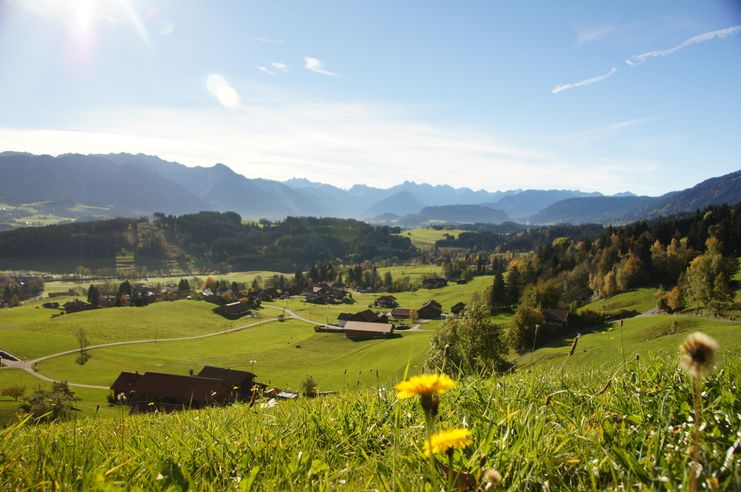
Varied and cozy through forests and over meadows. Great views, varied nature and small playgrounds along the way with refreshments.
- Strecke8,26 km
- Dauer3:00 h
- Aufstieg427 Hm
- Abstieg427 Hm
- Schwierigkeitmittel
Höhenprofil
An appealing hike through forests and and over meadows is waiting for you in Ofterschwang. Plenty of beautiful nature makes the tour a hiker's experience for the whole family. On the nature trail you will find exciting information about the origins and cultivation alpine landscape of the Allgäu. From the parking at the valley station of the cable car in Ofterschwang, the path leads via the nature trail to Hüttenberg. From here you go uphill passing "Alpe Eck" and the huts Hochbichl and Wurzelhütte again downhill to the valley station.
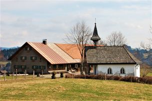
Tips: Combine the tour with a visit to the mountain-dairy in Hüttenberg - ideal for taking small treats along for the walk. At the Allgäuer Berghof at Alpe Eck, the DiscGolf Parcours invites you to play a round of Discgolf. Here, unlike golfing, a frizbee must be thrown in special baskets. You can relax in the sun on comfortable sofas at the rustic Hochbichl hut - the only alpine hut with outdoor sofas. The "Wurzelhütte" with a cozy restaurant, Schlitte Hitte with its great alpine ambience and the pizzeria in the Ofterschwanger Haus at the base station in Ofterschwang invite you to a cozy stopover.
From the parking at the valley station of the World Cup Express in Ofterschwang, the path leads to the right around the primary school. Follow the sign "Hüttenberg". Cross the river, you enter a small settlement and enter the nature trail, which tells interesting facts about the forest, plants and origins of the Allgäu Alps. At the end of the nature trail above Hüttenberg follow the path straight ahead and take the second path on the left to Gunzesried. Magnificent mountain meadows and beautiful forest sections lead up to Gunzesried / Allgäuer Berghof until you finally reach the road. The route continues along the road, past the Kuckucksnest (private) to the Familotel Allgäuer Berghof (no stopover). Here you have a beautiful panorama view into the entire valley. The path leads either left downhill to Ofterschwang, or you pass the hotel and after a small right-left loop to the Hochbichl hut (signposted). From here, go downhill for a short distance and then left-right with the Panoramweg downhill to Ofterschwang. We recommend avoiding the road straight down, because it is quite steep and difficult to walk.
Tips: Visit the alpine dairy in Hüttenberg. In addition to fine cheese and delicacies made from fresh hay-milk, you also get hearty sausage specialties from the Butchery (cooperative butcher shop). There is a disc golf course at the Allgäu Berghof. From Thursday to Sunday you can test your luck with Frizbees. Possibility for stop-over: At the valley station you will find the Schlitte Hitte, Pizzeria Cortina and the Wurzelhütte, on the way the Hochbichlhütte. In the summer months, the ice cream shop in the village center of Ofterschwang offers quality homemade ice cream made from our precious milk!
Öffentliche Verkehrsmittel
From Sonthofen train and bus station by bus to Ofterschwang (bus Sonthofen - Ofterschwang - Bolsterlang) or Fischen (via Bolsterlang)Schedule for buses and trains in the southern Upper Allgäu (german)
Ofterschwang is located on the edge of the Nature Park Nagelfluhkette. A Nature Park is a protected landscape created by long-term use and cultivation. This valuable cultural landscape is to be preserved in its present form, but at the same time also to be used.
Please note the following recommendations:
- Please do not make noise.
- Please do not go off the road.
- Please do not make an open fire.
- Please only camp on marked areas.
- Please do not resettle plants or animals.
- Please do not pick plants and flowers.
- Please do not collect mushrooms.
- Please do not collect stones or minerals.
- Please do not feed animals.
- Please do not leave any rubbish.
- Please dispose of dog droppings in public dog kennels or at home
The right equipment for your tour consists of proper hiking boots and clothing appropriate to the weather. Take sun cream and water along. Note that you are in the mountains and weather changes can be expected at any time.
Ähnliche Touren
- Wandertour
"Gutes vom Dorf" - Culinary hike through Ofterschwang
Tradition, untouched landscape and a lot of regional delicacies - that is what distinguishes Ofterschwang.
mehr dazuDistanz 11,8 km Dauer 3:30 h Aufstieg 309 m Schwierigkeit mittel - Wandertour
"Wiesengänger"-Trail
© Allgäu GmbH
The "Wasserläufer"-Route takes you through a beautiful hilly landscape on 463 km.
mehr dazuDistanz 424,8 km Dauer 107:30 h Aufstieg 5.300 m Schwierigkeit mittel - Wandertour
Border guard trail Oberreute/Allgaeu
Cross-border experience path for the whole family.
mehr dazuDistanz 9,1 km Dauer 2:30 h Aufstieg 173 m Schwierigkeit mittel - Wandertour
Castle ruin Falkenstein
Castle ruin Falkenstein
mehr dazuDistanz 7,8 km Dauer 3:00 h Aufstieg 530 m Schwierigkeit mittel - Wandertour
Family hike across Ochsenkopf via Riedberger Horn – climbing for kids
Family hike across Ochsenkopf via Riedberger Horn – climbing for kids
mehr dazuDistanz 12,9 km Dauer 4:23 h Aufstieg 591 m Schwierigkeit mittel - Wandertour
Hiking on the ridgeway ('Hoehenweg') from Scheidegg to the mountain Pfaender - the classic
The wonderful hiking tour leads you from Scheidegg through the German-Austrian alpine upland to the mountain Pfaender heighted 1064 meters. There you will be rewarded with an impressive panoramic view.
mehr dazuDistanz 10,9 km Dauer 3:30 h Aufstieg 415 m Schwierigkeit mittel - Wandertour
Hiking trail from Ofterschwang via Ofterschwanger Horn and Sigiswang
Scenic mountain tour to the Ofterschwanger Horn (peak).
mehr dazuDistanz 11,3 km Dauer 4:30 h Aufstieg 678 m Schwierigkeit mittel - Wandertour
Hochwiesweg Hike
A gorgeous little loop with beautiful views.
(pram friendly tour)
mehr dazuDistanz 3,9 km Dauer 1:00 h Aufstieg 120 m Schwierigkeit mittel - Wandertour
Hörner Panorama Tour - lovely mountain hike from Bolsterlang or Ofterschwang
This fantastic tour can start either in Bolsterlang or Ofterschwang and takes you over the popular Hörner Panorama Tour along the Weiherkopf, Rangiswanger Horn, Sigiswanger Horn and Ofterschwanger Horn.
mehr dazuDistanz 16,3 km Dauer 7:45 h Aufstieg 1.017 m Schwierigkeit mittel - Wandertour
Kapellenwanderung in Stiefenhofen
Kapellenwanderung in Stiefenhofen
mehr dazuDistanz 14,0 km Dauer 4:00 h Aufstieg 326 m Schwierigkeit mittel


Die Inhalte dieser Seite werden in Kooperation mit Outdooractive bereitgestellt.