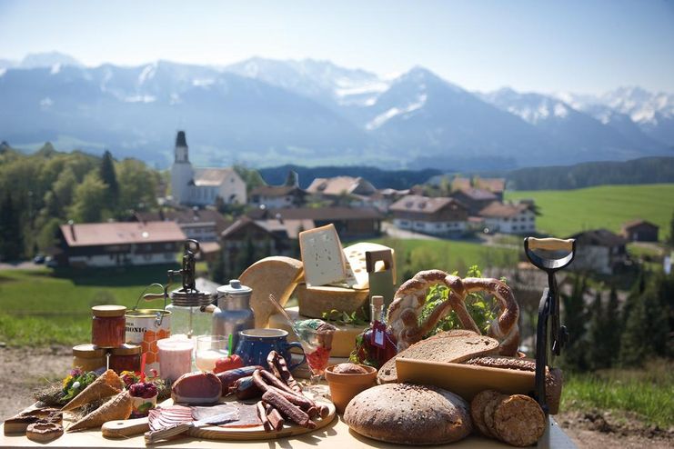
Tradition, untouched landscape and a lot of regional delicacies - that is what distinguishes Ofterschwang.
- Strecke11,80 km
- Dauer3:30 h
- Aufstieg309 Hm
- Abstieg333 Hm
- Schwierigkeitmittel
Höhenprofil
Enjoy a circular hike through the beautiful landscape of Ofterschwang. On the way you can visit both our alpine dairies in Hüttenberg and Schweinberg as well as the organic bakery in Westerhofen. As a tip we recommend a regional "Brotzeit". Ofterschwang offers many delicious homemade products from honey to cheese, bread, herbal products, sausages and much more.
You start the hike at the Ofterschwanger Haus, at the valley station of the Weltcup-Express. Leave Ofterschwang over the beautiful nature trail in the direction of Hüttenberg. There you can enjoy the different impressions of nature. The path leads along Bettenried, where the Bächle-Waibel herb garden is located. Waltraud Bächle-Waibel produces many herbal products from herbs, fruits and berries such as Marigold cream, holder liqueur, wild garlic oil, herbal teas, jams, etc.
Follow the nature trail to Hüttenberg. The mountain dairy prevails in this district. The well-known Bergbauern-Sennerei Hüttenberg is supplied with milk by all Hüttenberger farmers who work together in a cooperative and can thus produce the delicious cheese in their own production. Here you can buy genuine Allgäuer mountain cheese, herb cheese, butter etc. or take part in a guide through the dairy, which is always held on Thursdays at 10.15 am.
From the village center of Hüttenberg, you will have a wonderful view of Sonthofen and surroundings and head down to Westerhofen. Here you will find the organic bakery Kornblume, another local producer in Ofterschwang. The bakery has a small cozy café, where you can taste tasty whole-baked and organic breads of all kinds. In the village center you will find a small and cozy village square with a herbal spiral and seating for resting.
Continue your tour behind the chapel through the forest in the direction of Schweineberg, where you can hike between the tree giants in a quiet and idyllic atmosphere. On your way to Schweineberg, take a small stop on the Wittelsbacher Höhe, a scenic hilltop with an old tree ontop. A breathtaking panoramic view of the entire Illertal valley awaits you here. From the Wittelsbacher Höhe you follow the path over green meadows and you reach Schweineberg. There you will find another alpine dairy. In the alpine dairy Schweineberg you can participate in the alpine dairy every Tuesday at 10.30am. The products are all made exclusively from genuine Allgäuer mountain milk. You can stop at the Bauerngasthof Café Mayr, which has a lovely terrace and tasty local cuisine. From Schweineberg you can take a detour down to the Hotel Sonnenalp Resort and head into the Tiefenberger Moos (bog), or go on towards Wielenberg, back to Ofterschwang. On the way you will cross forests and meadows from which the bees produce healthy and tasty Allgäu honey. The excellent honey of our various beekeepers in Ofterschwang is available in the village shop in Ofterschwang.
The Landhotel Alphorn is located directly at the village entrance. Here you will find Jörg Pöschl, enthusiastic alphorn player and an eager fan of local produce. Together with his team he stands with full conviction behind the local products of Ofterschwang and also uses his own herbs from the garden for tasty dishes.
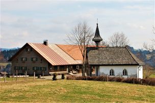
The last stage leads past the church of St. Alexander down into the village center to the ice cream parlour in Ofterschwang. The ice cream parlour only uses fresh milk from the mountain dairy Hüttenberg for its creative ice cream varieties. Even the other ingredients are regional as far as possible, or at least from organic cultivation or Fairtrade products. From the parlour it is only about 400m to the starting point - the valley station.
Anfahrt
The access to Ofterschwang is via the B19, with exit Sigishofen at Sonthofen or via Tiefenberg.Parken
Free parking at the Weltcup-Express base station in OfterschwangÖffentliche Verkehrsmittel
From Sonthofen train and bus station by bus to Ofterschwang (bus Sonthofen - Ofterschwang - Bolsterlang) or Fischen (via Bolsterlang)Ofterschwang is located on the edge of the Nature Park Nagelfluhkette. A Nature Park is a protected landscape created by long-term use and cultivation. This valuable cultural landscape is to be preserved in its present form, but at the same time also to be used.
Please note the following recommendations:
- Please do not make noise.
- Please do not go off the road.
- Please do not make an open fire.
- Please only camp on marked areas.
- Please do not resettle plants or animals.
- Please do not pick plants and flowers.
- Please do not collect mushrooms.
- Please do not collect stones or minerals.
- Please do not feed animals.
- Please do not leave any rubbish.
- Please dispose of dog droppings in public dog kennels or at home
The right equipment for your tour consists of proper hiking boots and clothing appropriate to the weather. This tour takes you along a partially exposed ridge. Take sun cream and water along. Note that you are in the mountains and weather changes can be expected at any time.
Ähnliche Touren
- Wandertour
"Wiesengänger"-Trail
© Allgäu GmbH
The "Wasserläufer"-Route takes you through a beautiful hilly landscape on 463 km.
mehr dazuDistanz 424,8 km Dauer 107:30 h Aufstieg 5.300 m Schwierigkeit mittel - Wandertour
Alpine Meadows - hiking tour from Ofterschwang
Varied and cozy through forests and over meadows. Great views, varied nature and small playgrounds along the way with refreshments.
mehr dazuDistanz 8,3 km Dauer 3:00 h Aufstieg 427 m Schwierigkeit mittel - Wandertour
Border guard trail Oberreute/Allgaeu
Cross-border experience path for the whole family.
mehr dazuDistanz 9,1 km Dauer 2:30 h Aufstieg 173 m Schwierigkeit mittel - Wandertour
Castle ruin Falkenstein
Castle ruin Falkenstein
mehr dazuDistanz 7,8 km Dauer 3:00 h Aufstieg 530 m Schwierigkeit mittel - Wandertour
Family hike across Ochsenkopf via Riedberger Horn – climbing for kids
Family hike across Ochsenkopf via Riedberger Horn – climbing for kids
mehr dazuDistanz 12,9 km Dauer 4:23 h Aufstieg 591 m Schwierigkeit mittel - Wandertour
Hiking on the ridgeway ('Hoehenweg') from Scheidegg to the mountain Pfaender - the classic
The wonderful hiking tour leads you from Scheidegg through the German-Austrian alpine upland to the mountain Pfaender heighted 1064 meters. There you will be rewarded with an impressive panoramic view.
mehr dazuDistanz 10,9 km Dauer 3:30 h Aufstieg 415 m Schwierigkeit mittel - Wandertour
Hiking trail from Ofterschwang via Ofterschwanger Horn and Sigiswang
Scenic mountain tour to the Ofterschwanger Horn (peak).
mehr dazuDistanz 11,3 km Dauer 4:30 h Aufstieg 678 m Schwierigkeit mittel - Wandertour
Hochwiesweg Hike
A gorgeous little loop with beautiful views.
(pram friendly tour)
mehr dazuDistanz 3,9 km Dauer 1:00 h Aufstieg 120 m Schwierigkeit mittel - Wandertour
Hörner Panorama Tour - lovely mountain hike from Bolsterlang or Ofterschwang
This fantastic tour can start either in Bolsterlang or Ofterschwang and takes you over the popular Hörner Panorama Tour along the Weiherkopf, Rangiswanger Horn, Sigiswanger Horn and Ofterschwanger Horn.
mehr dazuDistanz 16,3 km Dauer 7:45 h Aufstieg 1.017 m Schwierigkeit mittel - Wandertour
Kapellenwanderung in Stiefenhofen
Kapellenwanderung in Stiefenhofen
mehr dazuDistanz 14,0 km Dauer 4:00 h Aufstieg 326 m Schwierigkeit mittel


Die Inhalte dieser Seite werden in Kooperation mit Outdooractive bereitgestellt.