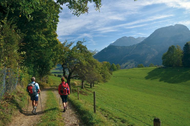
A panoramic and culturally very interesting stage with charming hamlets and idyllic riverside paths.
- Strecke21,35 km
- Dauer5:30 h
- Aufstieg310 Hm
- Abstieg405 Hm
- Schwierigkeitmittel
Höhenprofil
The Tyrol-Allgaeu Way of St James
This Alpine Route of St. James, which is both scenically and culturally very attractive, leads off the main roads over three Alpine passes, namely the Fernpass, the old Gaichtpass and the Jochpass. It crosses some of the most attractive hiking and holiday regions of Tyrol and southern Upper Allgäu on ancient Roman, trade and pilgrim paths.
The pilgrims to St. James can undoubtedly look forward to a particularly impressive route here. All the more so, as it mostly leads through rural, tranquil mountain regions, where people have been deeply influenced by faith and fear of the forces of nature for centuries. These regions are therefore particularly rich in churches and chapels with numerous art-historical gems, often from very different eras. In combination with the magnificent panoramic views, the constantly changing perspectives and the meditative, but now and then strenuous hiking in wind and weather through these alpine natural landscapes, this "camino" becomes an unforgettable path that demands all the senses, rich in intense experiences, encounters, experiential and perhaps also new insights about oneself.
Integration into the Jakobwegenetz of Austria and Germany
The Tyrol-Allgaeu Way of St. James connects in Stams to the German-Austrian Way of St. James from Munich along the Isar, Loisach, Leutascher Ache and Inn rivers, as well as to the two Austrian ways of St. James which unite in Innsbruck: the route from Lofer/Salzburg to Innsbruck and the route from Lienz to Innsbruck. From Innsbruck, this bundled stream of St. James' Way leads on via Stams to the Arlberg or even from Stams on the Tyrol-Allgaeu route.
Pilgrim's stamp and pilgrim's identity card
In the chapels of St. James and in the churches mentioned in the text there are stamped places along the St. James' Way. These pilgrim's stamps are nice memories in your own pilgrim's diary. In the intrnat. recognised pilgrim's identity card they serve as proof of the route completed. As an official document, the pilgrim's identity card also enables the pilgrim to stay overnight in special pilgrim accommodation, of which there are still few on this route. It can be obtained from the St. James pilgrim associations for a processing fee.
From St. Jodokus we go to Bad Hindelang to the Catholic Parish Church of St. John Baptist (built 1864-1867, stamped) with its numerous art treasures, including the famous triptych depicting the Corpus Christi procession. The only significant ascent on the German route leads (in the direction of "Zillenbachtobel") up to the sun-drenched hamlet of Gailenberg (989 m) with a magnificent view over the entire Ostrachtal. In the chapel of St. Silvester (built in 1623) the altarpiece is by Christian Modersohn, the son of the artist Otto Modersohn, who both lived here for several years. Today the studio of the painter Kilian Lipp is located in Gailenberg. On the quiet, chapel-rich and panoramic high-level trail, you pass Vorderhindelang, Reckenberg and Tiefenbach and descend to the bridge over the Ostrach - and into the Alpsee-Grünten holiday region. On the left bank, the trail leads via Binswangen in the direction of Sonthofen, the southernmost town in the Allgäu - ideal for a stroll along with an enjoyable lunch break. Then cross the Ostrach bridge at the Erzflöße in the north of the town and immediately after that turn left onto the path that leads through the floodplains to Ortwang, a district of Burgberg. Past the Ortwang quarry pond, keep right to get to the Illerbrücke bridge and cross it to the left towards Blaichach. Behind the bridge turn right and after the Schützenhaus you reach the Iller-Uferweg. Turn left there and follow the Illerdamm and the beautiful lakeside path, past the Inselsee with water ski lift and café, until you reach the turn-off to the centre of Immenstadt. The "Städtle" invites you to stay, especially around Marienplatz, Kirchplatz and Klosterplatz with the pink Capuchin church St. Josef. The catholic St. Nikolauskirche (stamped church) (mentioned in 1275) impresses with its baroque altars, the pulpit (1707) and a Mother of God (around 1470) from the famous Memmingen workshop of Ivo Strigel. Westwards, via the cattle market field, you reach the bathing path, which leads through the meadows past the Kleiner Alpsee, partly parallel to the railway line, to Bühl in the village centre on the shore of the Großer Alpsee - with lake stage, promenade, lido and AlpSeeHaus, the information centre of the Nagelfluhkette Nature Park with tourist information. You should allow enough time for this, the same applies to the pilgrimage church Maria Loreto (stamped) with Anna chapel, easily accessible via a steep little road from the AlpSeeHaus. The true-to-scale replica (1666) of the "Casa Santa", the Maria Loreto Chapel near Ancona (Italy), is fascinating - also due to its location with a distant view.
Anfahrt
Motorway A7 direction Füssen until Allgäuer Kreuz, continue on A980 direction until exit Waltenhofen. Take the B19 directly to Sonthofen, continue on the B308 to Bad Hindelang. Or on A7 to exit "Bad Hindelang-Oberjoch" near Oy- Mittelberg and on B309 via Oberjoch to Bad Hindelang (18 km).Parken
Public parking spaces in Bad Hindelang - subject to chargesÖffentliche Verkehrsmittel
The Sonthofen destination station is easily reached by train thanks to numerous direct connections. Further by bus shuttle to Hindelang (7 km) every half hour.
Selected literature for pilgrims, pilgrim diaries with prayers or aphorisms, scallops to wear around the neck or pilgrim's staffs can be found on the website: www.pilgerbox.de
It should be noted that there is an increased risk of accidents and injuries on pilgrim paths. Despite careful route planning, a basic risk always remains. Tour preparation through endurance sports, appropriate technical training and mental preparation reduces the risk of accidents and injuries. But please never forget that the weather in the mountains can change very quickly.
The personal pilgrim's equipment must be safe and serviceable and must meet the relevant technical standards. The rucksack should not exceed the weight of 15 kg. Every pilgrim is recommended to inform and prepare himself in detail in technical literature or on the Internet.
Ähnliche Touren
- Wandertour
"Gutes vom Dorf" - Culinary hike through Ofterschwang
Tradition, untouched landscape and a lot of regional delicacies - that is what distinguishes Ofterschwang.
mehr dazuDistanz 11,8 km Dauer 3:30 h Aufstieg 309 m Schwierigkeit mittel - Wandertour
"Wiesengänger"-Trail
© Allgäu GmbH
The "Wasserläufer"-Route takes you through a beautiful hilly landscape on 463 km.
mehr dazuDistanz 424,8 km Dauer 107:30 h Aufstieg 5.300 m Schwierigkeit mittel - Wandertour
Alpine Meadows - hiking tour from Ofterschwang
Varied and cozy through forests and over meadows. Great views, varied nature and small playgrounds along the way with refreshments.
mehr dazuDistanz 8,3 km Dauer 3:00 h Aufstieg 427 m Schwierigkeit mittel - Wandertour
Border guard trail Oberreute/Allgaeu
Cross-border experience path for the whole family.
mehr dazuDistanz 9,1 km Dauer 2:30 h Aufstieg 173 m Schwierigkeit mittel - Wandertour
Castle ruin Falkenstein
Castle ruin Falkenstein
mehr dazuDistanz 7,8 km Dauer 3:00 h Aufstieg 530 m Schwierigkeit mittel - Wandertour
Family hike across Ochsenkopf via Riedberger Horn – climbing for kids
Family hike across Ochsenkopf via Riedberger Horn – climbing for kids
mehr dazuDistanz 12,9 km Dauer 4:23 h Aufstieg 591 m Schwierigkeit mittel - Wandertour
Hiking on the ridgeway ('Hoehenweg') from Scheidegg to the mountain Pfaender - the classic
The wonderful hiking tour leads you from Scheidegg through the German-Austrian alpine upland to the mountain Pfaender heighted 1064 meters. There you will be rewarded with an impressive panoramic view.
mehr dazuDistanz 10,9 km Dauer 3:30 h Aufstieg 415 m Schwierigkeit mittel - Wandertour
Hiking trail from Ofterschwang via Ofterschwanger Horn and Sigiswang
Scenic mountain tour to the Ofterschwanger Horn (peak).
mehr dazuDistanz 11,3 km Dauer 4:30 h Aufstieg 678 m Schwierigkeit mittel - Wandertour
Hochwiesweg Hike
A gorgeous little loop with beautiful views.
(pram friendly tour)
mehr dazuDistanz 3,9 km Dauer 1:00 h Aufstieg 120 m Schwierigkeit mittel - Wandertour
Hörner Panorama Tour - lovely mountain hike from Bolsterlang or Ofterschwang
This fantastic tour can start either in Bolsterlang or Ofterschwang and takes you over the popular Hörner Panorama Tour along the Weiherkopf, Rangiswanger Horn, Sigiswanger Horn and Ofterschwanger Horn.
mehr dazuDistanz 16,3 km Dauer 7:45 h Aufstieg 1.017 m Schwierigkeit mittel


Die Inhalte dieser Seite werden in Kooperation mit Outdooractive bereitgestellt.