The spiritual attunement on the way takes place in the famous Cistercian monastery Stams with its art treasures as well as in the pilgrimage place Maria Locherboden above Mötz. Far from the main roads, the route leads through an enchanting landscape with many chapels.
- Strecke17,94 km
- Dauer5:30 h
- Aufstieg640 Hm
- Abstieg458 Hm
- Schwierigkeitmittel
Höhenprofil
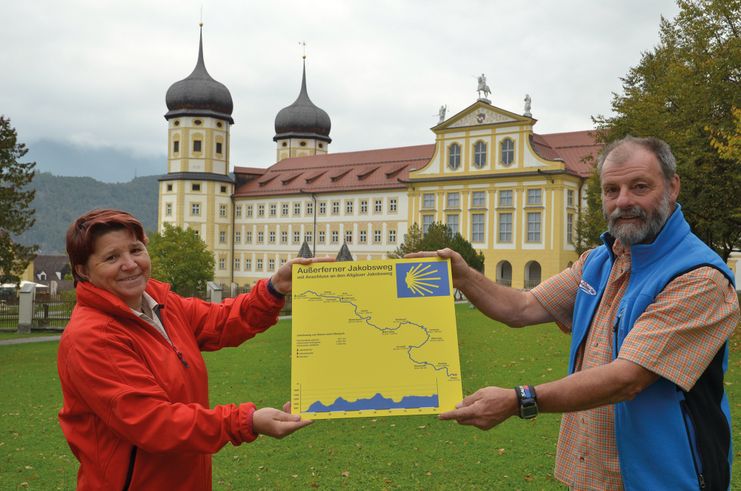
The Tyrol-Allgaeu Way of St James
This Alpine Route of St. James, which is both scenically and culturally very attractive, leads off the main roads over three Alpine passes, namely the Fernpass, the old Gaichtpass and the Jochpass. It crosses some of the most attractive hiking and holiday regions of Tyrol and southern Upper Allgäu on ancient Roman, trade and pilgrim paths.
The pilgrims to St. James can undoubtedly look forward to a particularly impressive route here. All the more so, as it mostly leads through rural, tranquil mountain regions, where people have been deeply influenced by faith and fear of the forces of nature for centuries. These regions are therefore particularly rich in churches and chapels with numerous art-historical gems, often from very different eras. In combination with the magnificent panoramic views, the constantly changing perspectives and the meditative, but now and then strenuous hiking in wind and weather through these alpine natural landscapes, this "camino" becomes an unforgettable path that demands all the senses, rich in intense experiences, encounters, experiential and perhaps also new insights about oneself.
Integration into the Jakobwegenetz of Austria and Germany
The Tyrol-Allgaeu Way of St. James connects in Stams to the German-Austrian Way of St. James from Munich along the Isar, Loisach, Leutascher Ache and Inn rivers, as well as to the two Austrian ways of St. James which unite in Innsbruck: the route from Lofer/Salzburg to Innsbruck and the route from Lienz to Innsbruck. From Innsbruck, this bundled stream of St. James' Way leads on via Stams to the Arlberg or even from Stams on the Tyrol-Allgaeu route.
Pilgrim's stamp and pilgrim's identity card
In the chapels of St. James and in the churches mentioned in the text there are stamped places along the St. James' Way. These pilgrim's stamps are nice memories in your own pilgrim's diary. In the intrnat. recognised pilgrim's identity card they serve as proof of the route completed. As an official document, the pilgrim's identity card also enables the pilgrim to stay overnight in special pilgrim accommodation, of which there are still few on this route. It can be obtained from the St. James pilgrim associations for a processing fee.
Stams Abbey is internationally known for its artistically restored baroque monastery church of the Assumption of the Virgin Mary, a "basilica minor", as well as for its masterpieces of sacred art. Right next to it is the Stams ski high school, from which many Austrian stars of skiing have emerged, including Anita Wachter, Stephan Eberharter and Gregor Schlierenzauer. From the Stams Abbey (stamp office) west through the Stamser Eichenwald, past the sports field and on towards Staudach. ATTENTION: here the paths Jakobsweg Tirol and Tirol/Allgäu separate. After the bridge in the Staudach district, head north towards Mötz railway station and the railway underpass. Continue over the bridge over the Inn to the centre of Mötz with the Florian's Fountain and the parish church Maria Schnee in baroque style. Behind the fountain you follow the marked path to the end of Königsgasse and hike along the partly narrow, steep gorge path up to the waterfall, which is about 25 metres high, and further on to the sunny plateau, which lies under the enormous rock faces of the Mieminger Kette. Burg Klamm (13th century) is privately owned. Afterwards you walk westwards along the panoramic salt transport path to the Chapel of Our Lady and to the Klammer Mill, where you take a short walk up to the right to the parish church of St. Joseph (completed in 1780) of Obsteig. About 600 metres then turn left along the main road until after the town hall of Obsteig you turn right into the larch meadows and walk in a westerly direction to Arzkasten. Shortly after the small Mariahilf chapel, the hamlet of Weisland follows with the chapel of the Assumption of the Virgin Mary (1985), where you can admire an altarpiece by Franz Anton Zeiller from Reutte, considered one of the most beautiful chapel paintings in Tyrol. From Holzleiten at the end of the village near the large chapel "Zur Heiligen Familie" the old Roman road leads steeply down to Dormitz with its pilgrimage church of St. Nicholas and a statue of James the Elder next to the high altar. However, the pilgrim path branches off sharply to the right after the first houses in Dormitz-Roßbach, directly in front of the campsite. The narrow Reitergassl runs behind the campsite and brook along the slope towards Nassereith until it forks at the edge of the forest with a view of the village. Here briefly uphill in the forest and along the climbing garden and Nassereither See directly to the neo-Romanesque parish church "Zu den Heiligen Drei Königen", with a gilded statue of St. James (around 1790) and frescoes in the Nazarene style.
Anfahrt
By car: Either via Innsbruck on the toll Inntal motorway towards Imst to Stams or via Reutte and the Fernpass to Nassereith or via Obsteig/Mieminger Sonnenplateau to Stams. From Munich via Seefeld/Tyrol to Telfs and on the Inntalautobahn in the direction of Haiming/Imst to Stams.Parken
Public parking spaces in Stams - partly with costsÖffentliche Verkehrsmittel
Overnight accommodation: In Stams, the junction of two Jacob's Way routes, there are simple pilgrim accommodation and meals for pilgrims with identification, e.g. at Camping Eichenwald, www.camping-eichenwald.at. For men also in the monastery. Accommodation in all categories in Obsteig, Holzleiten, Dormitz, Nassereith.
Selected literature for pilgrims, pilgrim diaries with prayers or aphorisms, scallops to wear around the neck or pilgrim's staffs can be found on the website: www.pilgerbox.de
It should be noted that there is an increased risk of accidents and injuries on pilgrim paths. Despite careful route planning, a basic risk always remains. Tour preparation through endurance sports, appropriate technical training and mental preparation reduces the risk of accidents and injuries. But please never forget that the weather in the mountains can change very quickly.
The personal pilgrim's equipment must be safe and serviceable and must meet the relevant technical standards. The rucksack should not exceed the weight of 15 kg. Every pilgrim is recommended to inform and prepare himself in detail in technical literature or on the Internet.
Ähnliche Touren
- Wandertour
"Gutes vom Dorf" - Culinary hike through Ofterschwang
Tradition, untouched landscape and a lot of regional delicacies - that is what distinguishes Ofterschwang.
mehr dazuDistanz 11,8 km Dauer 3:30 h Aufstieg 309 m Schwierigkeit mittel - Wandertour
"Wiesengänger"-Trail
© Allgäu GmbH
The "Wasserläufer"-Route takes you through a beautiful hilly landscape on 463 km.
mehr dazuDistanz 424,8 km Dauer 107:30 h Aufstieg 5.300 m Schwierigkeit mittel - Wandertour
Alpine Meadows - hiking tour from Ofterschwang
Varied and cozy through forests and over meadows. Great views, varied nature and small playgrounds along the way with refreshments.
mehr dazuDistanz 8,3 km Dauer 3:00 h Aufstieg 427 m Schwierigkeit mittel - Wandertour
Border guard trail Oberreute/Allgaeu
Cross-border experience path for the whole family.
mehr dazuDistanz 9,1 km Dauer 2:30 h Aufstieg 173 m Schwierigkeit mittel - Wandertour
Castle ruin Falkenstein
Castle ruin Falkenstein
mehr dazuDistanz 7,8 km Dauer 3:00 h Aufstieg 530 m Schwierigkeit mittel - Wandertour
Family hike across Ochsenkopf via Riedberger Horn – climbing for kids
Family hike across Ochsenkopf via Riedberger Horn – climbing for kids
mehr dazuDistanz 12,9 km Dauer 4:23 h Aufstieg 591 m Schwierigkeit mittel - Wandertour
Hiking on the ridgeway ('Hoehenweg') from Scheidegg to the mountain Pfaender - the classic
The wonderful hiking tour leads you from Scheidegg through the German-Austrian alpine upland to the mountain Pfaender heighted 1064 meters. There you will be rewarded with an impressive panoramic view.
mehr dazuDistanz 10,9 km Dauer 3:30 h Aufstieg 415 m Schwierigkeit mittel - Wandertour
Hiking trail from Ofterschwang via Ofterschwanger Horn and Sigiswang
Scenic mountain tour to the Ofterschwanger Horn (peak).
mehr dazuDistanz 11,3 km Dauer 4:30 h Aufstieg 678 m Schwierigkeit mittel - Wandertour
Hochwiesweg Hike
A gorgeous little loop with beautiful views.
(pram friendly tour)
mehr dazuDistanz 3,9 km Dauer 1:00 h Aufstieg 120 m Schwierigkeit mittel - Wandertour
Hörner Panorama Tour - lovely mountain hike from Bolsterlang or Ofterschwang
This fantastic tour can start either in Bolsterlang or Ofterschwang and takes you over the popular Hörner Panorama Tour along the Weiherkopf, Rangiswanger Horn, Sigiswanger Horn and Ofterschwanger Horn.
mehr dazuDistanz 16,3 km Dauer 7:45 h Aufstieg 1.017 m Schwierigkeit mittel


Die Inhalte dieser Seite werden in Kooperation mit Outdooractive bereitgestellt.