Hiking through the favorite landscape of the Bavarian kings - for pleasure hikers and castle fans.
Füssen Tourismus und Marketing
- Strecke15,35 km
- Dauer5:30 h
- Aufstieg700 Hm
- Abstieg700 Hm
- Schwierigkeitmittel
Höhenprofil
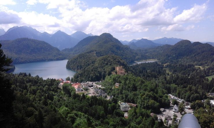
Following in the footsteps of Bavaria's fairytale king Ludwig II, this tour takes you through the densely wooded area between Füssen and the Säuling mountain range. With its shady stretches, this tour is also easily doable on hot summer days. The first part of the hike takes you through the old town of Füssen and to the top of the calvary, where you can enjoy the view of the town and the castles of Neuschwanstein and Hohenschwangau. A real insider tip is the hidden lake Schwansee with its orchid meadows halfway to the royal castles. Away from the village of Hohenschwangau, it is worth taking a detour to the Marys bridge, which offers the best photo view of Neuschwanstein Castle. Back in the village of Hohenschwangau, take a stairway into the courtyard of Hohenschwangau Castle and then past the mountain Berzenkopf and along the Alpenrosenweg to the Lech Falls near Füssen. From the Maxsteg you have the best view of the Lech Falls, where the river has made its way out of the mountains through a narrow gorge. Excitingly, the tour continues on the Path of the Senses in Bad Faulenbach (with a balancing path and barefoot trail) before climbing for the last time to the park at the High Castle.
Ähnliche Touren
- Wandertour
"Gutes vom Dorf" - Culinary hike through Ofterschwang
Tradition, untouched landscape and a lot of regional delicacies - that is what distinguishes Ofterschwang.
mehr dazuDistanz 11,8 km Dauer 3:30 h Aufstieg 309 m Schwierigkeit mittel - Wandertour
"Wiesengänger"-Trail
© Allgäu GmbH
The "Wasserläufer"-Route takes you through a beautiful hilly landscape on 463 km.
mehr dazuDistanz 424,8 km Dauer 107:30 h Aufstieg 5.300 m Schwierigkeit mittel - Wandertour
Alpine Meadows - hiking tour from Ofterschwang
Varied and cozy through forests and over meadows. Great views, varied nature and small playgrounds along the way with refreshments.
mehr dazuDistanz 8,3 km Dauer 3:00 h Aufstieg 427 m Schwierigkeit mittel - Wandertour
Border guard trail Oberreute/Allgaeu
Cross-border experience path for the whole family.
mehr dazuDistanz 9,1 km Dauer 2:30 h Aufstieg 173 m Schwierigkeit mittel - Wandertour
Castle ruin Falkenstein
Castle ruin Falkenstein
mehr dazuDistanz 7,8 km Dauer 3:00 h Aufstieg 530 m Schwierigkeit mittel - Wandertour
Family hike across Ochsenkopf via Riedberger Horn – climbing for kids
Family hike across Ochsenkopf via Riedberger Horn – climbing for kids
mehr dazuDistanz 12,9 km Dauer 4:23 h Aufstieg 591 m Schwierigkeit mittel - Wandertour
Hiking on the ridgeway ('Hoehenweg') from Scheidegg to the mountain Pfaender - the classic
The wonderful hiking tour leads you from Scheidegg through the German-Austrian alpine upland to the mountain Pfaender heighted 1064 meters. There you will be rewarded with an impressive panoramic view.
mehr dazuDistanz 10,9 km Dauer 3:30 h Aufstieg 415 m Schwierigkeit mittel - Wandertour
Hiking trail from Ofterschwang via Ofterschwanger Horn and Sigiswang
Scenic mountain tour to the Ofterschwanger Horn (peak).
mehr dazuDistanz 11,3 km Dauer 4:30 h Aufstieg 678 m Schwierigkeit mittel - Wandertour
Hochwiesweg Hike
A gorgeous little loop with beautiful views.
(pram friendly tour)
mehr dazuDistanz 3,9 km Dauer 1:00 h Aufstieg 120 m Schwierigkeit mittel - Wandertour
Hörner Panorama Tour - lovely mountain hike from Bolsterlang or Ofterschwang
This fantastic tour can start either in Bolsterlang or Ofterschwang and takes you over the popular Hörner Panorama Tour along the Weiherkopf, Rangiswanger Horn, Sigiswanger Horn and Ofterschwanger Horn.
mehr dazuDistanz 16,3 km Dauer 7:45 h Aufstieg 1.017 m Schwierigkeit mittel


Die Inhalte dieser Seite werden in Kooperation mit Outdooractive bereitgestellt.