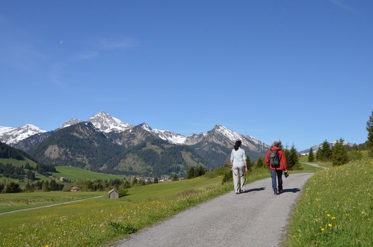
A varied circular hike through the Tannheimer Tal.
Tannheimer Tal
- Strecke43,24 km
- Dauer10:00 h
- Aufstieg683 Hm
- Abstieg678 Hm
- Schwierigkeitmittel
Höhenprofil
Along the circular hiking trail you can comfortably explore the "most beautiful high valley in Europe". On the way there are many places to stop for a bite to eat and beautiful places to enjoy.
From Tannheim in eastern direction of the valley, above the main road to Haldensee (approx. 1 hour). Then along the southern shore of Haldensee, past the Nesselwänlger Schmitte and further on until shortly before the Rauth turn-off (approx. 1 1/2 hours). At the underpass of the cycle and hiking trail, the circular trail leads back to Nesselwängle above (approx. 1/2 hour), further on to Haller (approx. 1/2 hour) and along the northern shore of Haldensee to Grän (approx. 1 hour). From here on the sunny side on the high-level trail through Berg to Zöblen (approx. 1 1/2 hours), further on via Kappl in the direction of Kalbelehof into the Vilstal. Along the Vils, past the large panorama board, see signpost, approx. 100 m back, cross the Vils on the two large wooden bridges and on the other side approx. 100 meters of steep ascent to Rehbach (approx. 2 hours). From Rehbach first on the asphalt road and then on the meadow path to the reservoir, further on to Schattwald and Zöblen and over the Rohnenwiesen past the Höfersee to Tannheim (approx. 2 1/2 hours).
Translated with www.DeepL.com/Translator (free version)
Anfahrt
On the motorway A7 at the exit "Oy-Mittelberg" on the B310 towards Wertach and to Oberjoch. There follow the signposting "Tannheimer Tal" B199, exit Tannheim. From the Tyrolean side via Reutte on the B198 towards Lechtal until Weißenbach, over the Gaichtpass along the B199 until exit Tannheim.Parken
Public parking spaces in Tannheim - with costsÖffentliche Verkehrsmittel
By train to Sonthofen, Pfronten/Ried or Reutte, then by bus to Tannheim.
No special safety instructions to be observed. Good footwear, possibly sun or rain protection and take something to drink with you.
An up-to-date and well-kept/maintained equipment (shoes, sticks and clothes) not only provides a considerable degree of safety but also makes hiking much easier. Sun protection (high protection factor and possibly sunglasses) as well as sufficient liquid should not be forgotten.
Ähnliche Touren
- Wandertour
"Gutes vom Dorf" - Culinary hike through Ofterschwang
Tradition, untouched landscape and a lot of regional delicacies - that is what distinguishes Ofterschwang.
mehr dazuDistanz 11,8 km Dauer 3:30 h Aufstieg 309 m Schwierigkeit mittel - Wandertour
"Wiesengänger"-Trail
© Allgäu GmbH
The "Wasserläufer"-Route takes you through a beautiful hilly landscape on 463 km.
mehr dazuDistanz 424,8 km Dauer 107:30 h Aufstieg 5.300 m Schwierigkeit mittel - Wandertour
Alpine Meadows - hiking tour from Ofterschwang
Varied and cozy through forests and over meadows. Great views, varied nature and small playgrounds along the way with refreshments.
mehr dazuDistanz 8,3 km Dauer 3:00 h Aufstieg 427 m Schwierigkeit mittel - Wandertour
Border guard trail Oberreute/Allgaeu
Cross-border experience path for the whole family.
mehr dazuDistanz 9,1 km Dauer 2:30 h Aufstieg 173 m Schwierigkeit mittel - Wandertour
Castle ruin Falkenstein
Castle ruin Falkenstein
mehr dazuDistanz 7,8 km Dauer 3:00 h Aufstieg 530 m Schwierigkeit mittel - Wandertour
Family hike across Ochsenkopf via Riedberger Horn – climbing for kids
Family hike across Ochsenkopf via Riedberger Horn – climbing for kids
mehr dazuDistanz 12,9 km Dauer 4:23 h Aufstieg 591 m Schwierigkeit mittel - Wandertour
Hiking on the ridgeway ('Hoehenweg') from Scheidegg to the mountain Pfaender - the classic
The wonderful hiking tour leads you from Scheidegg through the German-Austrian alpine upland to the mountain Pfaender heighted 1064 meters. There you will be rewarded with an impressive panoramic view.
mehr dazuDistanz 10,9 km Dauer 3:30 h Aufstieg 415 m Schwierigkeit mittel - Wandertour
Hiking trail from Ofterschwang via Ofterschwanger Horn and Sigiswang
Scenic mountain tour to the Ofterschwanger Horn (peak).
mehr dazuDistanz 11,3 km Dauer 4:30 h Aufstieg 678 m Schwierigkeit mittel - Wandertour
Hochwiesweg Hike
A gorgeous little loop with beautiful views.
(pram friendly tour)
mehr dazuDistanz 3,9 km Dauer 1:00 h Aufstieg 120 m Schwierigkeit mittel - Wandertour
Hörner Panorama Tour - lovely mountain hike from Bolsterlang or Ofterschwang
This fantastic tour can start either in Bolsterlang or Ofterschwang and takes you over the popular Hörner Panorama Tour along the Weiherkopf, Rangiswanger Horn, Sigiswanger Horn and Ofterschwanger Horn.
mehr dazuDistanz 16,3 km Dauer 7:45 h Aufstieg 1.017 m Schwierigkeit mittel


Die Inhalte dieser Seite werden in Kooperation mit Outdooractive bereitgestellt.