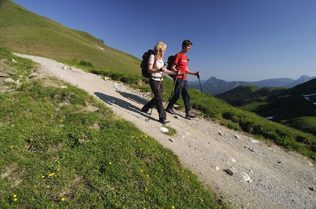
A wonderful hike through the beautiful Pontental over the Zirleseck to the Älpele. A wonderful world of peaks is waiting for you.
TVB Tannheimer Tal
- Strecke11,13 km
- Dauer5:30 h
- Aufstieg800 Hm
- Abstieg800 Hm
- Schwierigkeitmittel
Höhenprofil
From the lift car park in Zöblen, the route goes uphill into the Ponta valley almost parallel to the ski slope. This beautiful valley between Rohnenspitze and Ponten even has a small lake at the back of the valley. The end of the Pontental is a slope to the Zirleseck. From there you can see far into the Alps and also into the Allgäu. After a few meters towards the Geißhorn, which stands imposingly in front of us, we turn left, downhill to the Älpele, a managed alpine hut, and further downhill out of the Älpele valley. On the way back we make a detour to the Höfersee, a small pearl in this landscape. Over a high trail with a great view we reach Zöblen again.
We meet at the lift parking lot in Zöblen. In southern direction we see the Rohnenspitze, to the right of it the Ponten and in between the Pontental, a destination of our hike today. The newly built 4-seater chair lift would take away a lot of time and sweat, but the lift only runs in winter skiing.So we climb uphill, passing the Restaurant Auszeit and the Augsburger Häuschen.A narrow, moderately steep hiking trail leads us mostly through the forest, but steadily upwards. Partly we see or cross the forest path. This is flatter, but also much longer. Once again we cross the ski slope and have reached the entrance to the Ponta Valley. Without marking, the inconspicuous path would almost not be visible. Lined by beautiful scenery, the path continues on and on into the Pontental. Huge boulders line the path and give you a glimpse of the force of nature when it breaks off. Suddenly the terrain becomes a bit flatter and gives us time to take a deep breath. Even a small lake, which slowly grows, is up here.Chamois often meet here to drink or just to cool off. We also hear some marmots whistling to warn their conspecifics as soon as they spot us.Looking ahead, we see a steeper slope where the path can only be guessed at. This slope leads us to the Zirleseck. But also this hurdle is taken by us and the view up here compensates for the efforts. To the left of us, not far from the summit, is the Rohnenspitze, to the right the Ponten and almost in front of us the Geißhorn. Our view wanders far over the alpine peaks, but also the view down into the Tannheimer Tal is not to be despised. And the Willersalpe, lying below us towards the Hintersteinertal, rounds off the harmonious landscape idyll.From now on it goes downhill.First through mountain pines and later on alpine meadow paths. The fence, over which we have to climb twice, not only serves as a fence for the grazing animals, here the state border to Germany runs. The path leads us slightly downhill until the sign shows us to the left over a steeper slope to the Älpele. Down in the flat we already see the hut, which is also reached relatively quickly. Since the Älpele is farmed and we are still on the road early, we take a break.The further descent we make on the gravel forest path, which is a little longer, but not so steep. With the explanation of some plants and the always beautiful view we pass the time until we reach the turnoff to the Höfersee. A narrow path now leads to the left, across the small stream and through the forest. We almost believe that we have lost our way. Only when the wide forest path is in front of us again, we are sure to have chosen the right direction. A few more moments, then we have reached the Höfersee. A short detour to the lake a few meters away should also be enough time.You should have seen this little pearl in the middle of the forest and pasture landscape. We continue in direction Zöblen. Horses, cows and calves, which spend the whole summer up here, come curiously to us. Shortly before the end of the hike we walk on a farm track above Zöblen. From here we have a great view over almost the entire Tannheimer Tal - from Schattwald to Haldensee. Many mountains, including Gimpel and Rote Flüh, can also be seen very well from here.Above Zöblen we pass a Kneipp basin. Those who feel like cooling their feet now have the opportunity to do so. The last meters are soon done and we reach the parking lot. We say goodbye and those who take the hiking bus to the accommodation go to the nearby bus stop.
Anfahrt
On the motorway A7 at the exit "Oy-Mittelberg" on the B310 towards Wertach and to Oberjoch. There follow the signposting "Tannheimer Tal" B199, exit Zöblen, lift car park Zöblen.From the Tyrolean side via Reutte on the B198 in the direction of Lechtal to Weißenbach, over the Gaichtpass along the B199 to the exit Zöblen, lift car park Zöblen.Parken
Lift parking in ZöblenÖffentliche Verkehrsmittel
By train to Sonthofen, Pfronten/Ried or Reutte, then by bus to Zöblen.
It should be noted that in mountaineering there is an increased risk of accidents and injuries. Despite careful route planning, a basic risk always remains. Tour preparation through endurance sports, appropriate technical training and further education as well as personal prudence reduces the danger of accidents and risks. However, please never forget that the weather in the mountains can change very quickly. Stay on the marked hiking trails.
The personal mountaineering equipment must be safe and serviceable and meet the relevant technical standards. Every hiker is recommended to obtain information about the planned tours from specialist alpine literature or on site.
Ähnliche Touren
- Wandertour
"Gutes vom Dorf" - Culinary hike through Ofterschwang
Tradition, untouched landscape and a lot of regional delicacies - that is what distinguishes Ofterschwang.
mehr dazuDistanz 11,8 km Dauer 3:30 h Aufstieg 309 m Schwierigkeit mittel - Wandertour
"Wiesengänger"-Trail
© Allgäu GmbH
The "Wasserläufer"-Route takes you through a beautiful hilly landscape on 463 km.
mehr dazuDistanz 424,8 km Dauer 107:30 h Aufstieg 5.300 m Schwierigkeit mittel - Wandertour
Alpine Meadows - hiking tour from Ofterschwang
Varied and cozy through forests and over meadows. Great views, varied nature and small playgrounds along the way with refreshments.
mehr dazuDistanz 8,3 km Dauer 3:00 h Aufstieg 427 m Schwierigkeit mittel - Wandertour
Border guard trail Oberreute/Allgaeu
Cross-border experience path for the whole family.
mehr dazuDistanz 9,1 km Dauer 2:30 h Aufstieg 173 m Schwierigkeit mittel - Wandertour
Castle ruin Falkenstein
Castle ruin Falkenstein
mehr dazuDistanz 7,8 km Dauer 3:00 h Aufstieg 530 m Schwierigkeit mittel - Wandertour
Family hike across Ochsenkopf via Riedberger Horn – climbing for kids
Family hike across Ochsenkopf via Riedberger Horn – climbing for kids
mehr dazuDistanz 12,9 km Dauer 4:23 h Aufstieg 591 m Schwierigkeit mittel - Wandertour
Hiking on the ridgeway ('Hoehenweg') from Scheidegg to the mountain Pfaender - the classic
The wonderful hiking tour leads you from Scheidegg through the German-Austrian alpine upland to the mountain Pfaender heighted 1064 meters. There you will be rewarded with an impressive panoramic view.
mehr dazuDistanz 10,9 km Dauer 3:30 h Aufstieg 415 m Schwierigkeit mittel - Wandertour
Hiking trail from Ofterschwang via Ofterschwanger Horn and Sigiswang
Scenic mountain tour to the Ofterschwanger Horn (peak).
mehr dazuDistanz 11,3 km Dauer 4:30 h Aufstieg 678 m Schwierigkeit mittel - Wandertour
Hochwiesweg Hike
A gorgeous little loop with beautiful views.
(pram friendly tour)
mehr dazuDistanz 3,9 km Dauer 1:00 h Aufstieg 120 m Schwierigkeit mittel - Wandertour
Hörner Panorama Tour - lovely mountain hike from Bolsterlang or Ofterschwang
This fantastic tour can start either in Bolsterlang or Ofterschwang and takes you over the popular Hörner Panorama Tour along the Weiherkopf, Rangiswanger Horn, Sigiswanger Horn and Ofterschwanger Horn.
mehr dazuDistanz 16,3 km Dauer 7:45 h Aufstieg 1.017 m Schwierigkeit mittel


Die Inhalte dieser Seite werden in Kooperation mit Outdooractive bereitgestellt.