Enjoy the extended hike with a special kind of nature experience!.
- Strecke16,06 km
- Dauer6:18 h
- Aufstieg1188 Hm
- Abstieg1258 Hm
- Schwierigkeitmittel
Höhenprofil
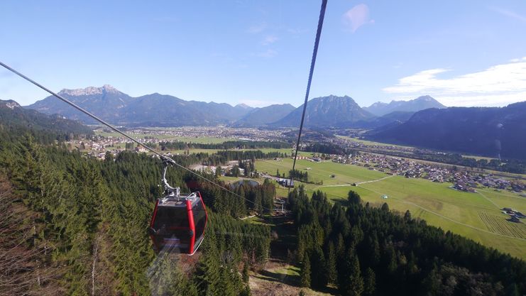
From the top station of the Hahnenkamm cable car, the Alpenrosenweg leads past the natural Alpine flower garden, which is no longer maintained.
Ascent with the Hahnenkamm cable car to the top station. From there, turn right along the Alpenrosenweg to the Gehrenalpe (overnight accommodation available), continue to the Gehrenjoch and Sabachjoch and then descend to the Musauer Alm (overnight accommodation available). From the Musauer Alm, a forest path leads down to the Bärenfalle in the village of Musau with 400 inhabitants. From there you can take the train to Reutte and the public bus back to Höfen to the valley station or car park of the Reutten cable car.
Anfahrt
Take the A7 motorway to Füssen, follow the B179 through the border tunnel to Reutte/Tyrol, turn off there onto the B198 and turn right in the Höfen area towards the Hahnenkammbahn lift, as far as the valley station.Parken
Parking bottom station HahnenkammbahnÖffentliche Verkehrsmittel
By train to Reutte, then by bus to Höfen (tourist office).
It should be noted that in mountaineering there is an increased risk of accidents and injuries. Despite careful route planning, a basic risk always remains. Tour preparation through endurance sports, appropriate technical training and further education as well as personal prudence reduces the danger of accidents and risks. However, please never forget that the weather in the mountains can change very quickly. Stay on the marked hiking trails.
The personal mountaineering equipment must be safe and serviceable and meet the relevant technical standards. Every hiker is recommended to obtain information about the planned tours from specialist alpine literature or on site.
Ähnliche Touren
- Wandertour
"Gutes vom Dorf" - Culinary hike through Ofterschwang
Tradition, untouched landscape and a lot of regional delicacies - that is what distinguishes Ofterschwang.
mehr dazuDistanz 11,8 km Dauer 3:30 h Aufstieg 309 m Schwierigkeit mittel - Wandertour
"Wiesengänger"-Trail
© Allgäu GmbH
The "Wasserläufer"-Route takes you through a beautiful hilly landscape on 463 km.
mehr dazuDistanz 424,8 km Dauer 107:30 h Aufstieg 5.300 m Schwierigkeit mittel - Wandertour
Alpine Meadows - hiking tour from Ofterschwang
Varied and cozy through forests and over meadows. Great views, varied nature and small playgrounds along the way with refreshments.
mehr dazuDistanz 8,3 km Dauer 3:00 h Aufstieg 427 m Schwierigkeit mittel - Wandertour
Border guard trail Oberreute/Allgaeu
Cross-border experience path for the whole family.
mehr dazuDistanz 9,1 km Dauer 2:30 h Aufstieg 173 m Schwierigkeit mittel - Wandertour
Castle ruin Falkenstein
Castle ruin Falkenstein
mehr dazuDistanz 7,8 km Dauer 3:00 h Aufstieg 530 m Schwierigkeit mittel - Wandertour
Family hike across Ochsenkopf via Riedberger Horn – climbing for kids
Family hike across Ochsenkopf via Riedberger Horn – climbing for kids
mehr dazuDistanz 12,9 km Dauer 4:23 h Aufstieg 591 m Schwierigkeit mittel - Wandertour
Hiking on the ridgeway ('Hoehenweg') from Scheidegg to the mountain Pfaender - the classic
The wonderful hiking tour leads you from Scheidegg through the German-Austrian alpine upland to the mountain Pfaender heighted 1064 meters. There you will be rewarded with an impressive panoramic view.
mehr dazuDistanz 10,9 km Dauer 3:30 h Aufstieg 415 m Schwierigkeit mittel - Wandertour
Hiking trail from Ofterschwang via Ofterschwanger Horn and Sigiswang
Scenic mountain tour to the Ofterschwanger Horn (peak).
mehr dazuDistanz 11,3 km Dauer 4:30 h Aufstieg 678 m Schwierigkeit mittel - Wandertour
Hochwiesweg Hike
A gorgeous little loop with beautiful views.
(pram friendly tour)
mehr dazuDistanz 3,9 km Dauer 1:00 h Aufstieg 120 m Schwierigkeit mittel - Wandertour
Hörner Panorama Tour - lovely mountain hike from Bolsterlang or Ofterschwang
This fantastic tour can start either in Bolsterlang or Ofterschwang and takes you over the popular Hörner Panorama Tour along the Weiherkopf, Rangiswanger Horn, Sigiswanger Horn and Ofterschwanger Horn.
mehr dazuDistanz 16,3 km Dauer 7:45 h Aufstieg 1.017 m Schwierigkeit mittel


Die Inhalte dieser Seite werden in Kooperation mit Outdooractive bereitgestellt.