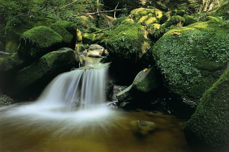
Cascades, former mills andf a moor worth seeing - the half-day hikimng tour following the 'Tobelbach' is a varied tour good to master with children also.
- Strecke12,97 km
- Dauer3:00 h
- Aufstieg127 Hm
- Abstieg127 Hm
- Schwierigkeitmittel
Höhenprofil
Starting at the parking space in Roethenbach the way leads you, passing the old public swimming pool to a forest and root path that always runs along the murmuring creek Tobelbach and under a railway bridge that is 36 meters high and 112 meters long. The impressive bridge has been built already in the 19th century. After a short climb to the forest's edge at the village boarder of Ellhofen, the tour continues on the ''Tobelrandweg'' with its good prospects. After that, you descend to the 'Tobelmühle' (ravine mill). The history of the former mill can be traced back to the 15th century. The narrow forest path leads to the former hammer mill,always following the creek. Just few meters away, the water of the Tobelbach flows downhill via rushing cascades. A detour leads you to the 'Lerchenmühle', a former mill that can also be traced back to the 15th century. Leaving the ravine you get to the 'Burghof'. Some ruins are reminders of the castle built before the year 1300 which was the residence of the Lords of Ellhofen. Via Ellhofen (water trample basin) and the former public swimming pool, the tour continues towards Rentershofen and to the moor 'Roethenbacher Moor' with its comparatively pristine wetlands. Few minutes later, you are back in Roethenbach.
Ähnliche Touren
- Wandertour
"Gutes vom Dorf" - Culinary hike through Ofterschwang
Tradition, untouched landscape and a lot of regional delicacies - that is what distinguishes Ofterschwang.
mehr dazuDistanz 11,8 km Dauer 3:30 h Aufstieg 309 m Schwierigkeit mittel - Wandertour
"Wiesengänger"-Trail
© Allgäu GmbH
The "Wasserläufer"-Route takes you through a beautiful hilly landscape on 463 km.
mehr dazuDistanz 424,8 km Dauer 107:30 h Aufstieg 5.300 m Schwierigkeit mittel - Wandertour
Alpine Meadows - hiking tour from Ofterschwang
Varied and cozy through forests and over meadows. Great views, varied nature and small playgrounds along the way with refreshments.
mehr dazuDistanz 8,3 km Dauer 3:00 h Aufstieg 427 m Schwierigkeit mittel - Wandertour
Border guard trail Oberreute/Allgaeu
Cross-border experience path for the whole family.
mehr dazuDistanz 9,1 km Dauer 2:30 h Aufstieg 173 m Schwierigkeit mittel - Wandertour
Castle ruin Falkenstein
Castle ruin Falkenstein
mehr dazuDistanz 7,8 km Dauer 3:00 h Aufstieg 530 m Schwierigkeit mittel - Wandertour
Family hike across Ochsenkopf via Riedberger Horn – climbing for kids
Family hike across Ochsenkopf via Riedberger Horn – climbing for kids
mehr dazuDistanz 12,9 km Dauer 4:23 h Aufstieg 591 m Schwierigkeit mittel - Wandertour
Hiking on the ridgeway ('Hoehenweg') from Scheidegg to the mountain Pfaender - the classic
The wonderful hiking tour leads you from Scheidegg through the German-Austrian alpine upland to the mountain Pfaender heighted 1064 meters. There you will be rewarded with an impressive panoramic view.
mehr dazuDistanz 10,9 km Dauer 3:30 h Aufstieg 415 m Schwierigkeit mittel - Wandertour
Hiking trail from Ofterschwang via Ofterschwanger Horn and Sigiswang
Scenic mountain tour to the Ofterschwanger Horn (peak).
mehr dazuDistanz 11,3 km Dauer 4:30 h Aufstieg 678 m Schwierigkeit mittel - Wandertour
Hochwiesweg Hike
A gorgeous little loop with beautiful views.
(pram friendly tour)
mehr dazuDistanz 3,9 km Dauer 1:00 h Aufstieg 120 m Schwierigkeit mittel - Wandertour
Hörner Panorama Tour - lovely mountain hike from Bolsterlang or Ofterschwang
This fantastic tour can start either in Bolsterlang or Ofterschwang and takes you over the popular Hörner Panorama Tour along the Weiherkopf, Rangiswanger Horn, Sigiswanger Horn and Ofterschwanger Horn.
mehr dazuDistanz 16,3 km Dauer 7:45 h Aufstieg 1.017 m Schwierigkeit mittel


Die Inhalte dieser Seite werden in Kooperation mit Outdooractive bereitgestellt.