A wonderful hike to the local mountain of Tannheim.
- Strecke6,39 km
- Dauer6:10 h
- Aufstieg762 Hm
- Abstieg838 Hm
- Schwierigkeitmittel
Höhenprofil
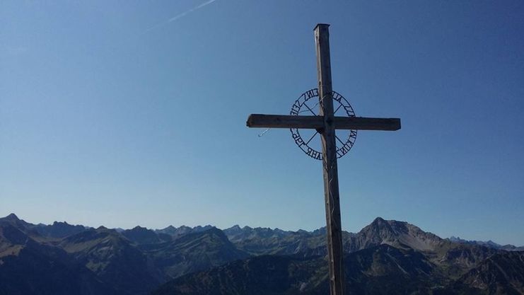
Starting from Tannheim through the romantic village of Berg, then we dive into an untouched forest until we reach the foot of the mighty Einstein. An indescribable view from the summit awaits you. Afterwards we descend to the northern side of the Einsteins back into the Engetal.
The car park at the underpass in Tannheim, in the direction of the Berg district, is the starting point of our hike. Eastwards through the district of Berg, the goal, the Einstein always in sight, the trail slowly climbs. Following the signs, we cross the road a few times and then, after passing through a turnstile, we continue upwards over pastureland.On a tree hangs a "Marterl", a memory of a mountain hiker who died in a fatal accident. From now on it gets a bit steeper and the path changes to gravel. Some serpentines go up. Finally we have reached the ridge and on the other side we see the Engetal. The route continues along the ridge towards the summit. Shortly below the summit it becomes rocky and we pay special attention again. The summit rewards us with wonderful panoramic views. The descent begins with a short stretch on the same path along the ridge before it turns left into the Engetal. At first the path leads us over gravelly ground, then over pasture land and finally through wooded areas. A parking lot, where the German customs house used to stand, is the destination of our hike today. We return to the Tannheimer Tal either with the hiking bus or with our own car.
Anfahrt
On the motorway A7 at the exit "Oy-Mittelberg" on the B310 towards Wertach and to Oberjoch. There follow the signposting "Tannheimer Tal" B199, exit Tannheim, car park at the district Berg.From the Tyrolean side via Reutte on the B198 towards Lechtal to Weißenbach, over the Gaichtpass along the B199 to the exit Tannheim, car park at the district Berg.Parken
Parking at the Berg district - parking feeÖffentliche Verkehrsmittel
By train to Sonthofen, Pfronten/Ried or Reutte, then by bus to Tannheim.
It should be noted that in mountaineering there is an increased risk of accidents and injuries. Despite careful route planning, a basic risk always remains. Tour preparation through endurance sports, appropriate technical training and further education as well as personal prudence reduces the danger of accidents and risks. However, please never forget that the weather in the mountains can change very quickly. Stay on the marked hiking trails.
The personal mountaineering equipment must be safe and serviceable and meet the relevant technical standards. Every hiker is recommended to obtain information about the planned tours from specialist alpine literature or on site.
Ähnliche Touren
- Wandertour
"Gutes vom Dorf" - Culinary hike through Ofterschwang
Tradition, untouched landscape and a lot of regional delicacies - that is what distinguishes Ofterschwang.
mehr dazuDistanz 11,8 km Dauer 3:30 h Aufstieg 309 m Schwierigkeit mittel - Wandertour
"Wiesengänger"-Trail
© Allgäu GmbH
The "Wasserläufer"-Route takes you through a beautiful hilly landscape on 463 km.
mehr dazuDistanz 424,8 km Dauer 107:30 h Aufstieg 5.300 m Schwierigkeit mittel - Wandertour
Alpine Meadows - hiking tour from Ofterschwang
Varied and cozy through forests and over meadows. Great views, varied nature and small playgrounds along the way with refreshments.
mehr dazuDistanz 8,3 km Dauer 3:00 h Aufstieg 427 m Schwierigkeit mittel - Wandertour
Border guard trail Oberreute/Allgaeu
Cross-border experience path for the whole family.
mehr dazuDistanz 9,1 km Dauer 2:30 h Aufstieg 173 m Schwierigkeit mittel - Wandertour
Castle ruin Falkenstein
Castle ruin Falkenstein
mehr dazuDistanz 7,8 km Dauer 3:00 h Aufstieg 530 m Schwierigkeit mittel - Wandertour
Family hike across Ochsenkopf via Riedberger Horn – climbing for kids
Family hike across Ochsenkopf via Riedberger Horn – climbing for kids
mehr dazuDistanz 12,9 km Dauer 4:23 h Aufstieg 591 m Schwierigkeit mittel - Wandertour
Hiking on the ridgeway ('Hoehenweg') from Scheidegg to the mountain Pfaender - the classic
The wonderful hiking tour leads you from Scheidegg through the German-Austrian alpine upland to the mountain Pfaender heighted 1064 meters. There you will be rewarded with an impressive panoramic view.
mehr dazuDistanz 10,9 km Dauer 3:30 h Aufstieg 415 m Schwierigkeit mittel - Wandertour
Hiking trail from Ofterschwang via Ofterschwanger Horn and Sigiswang
Scenic mountain tour to the Ofterschwanger Horn (peak).
mehr dazuDistanz 11,3 km Dauer 4:30 h Aufstieg 678 m Schwierigkeit mittel - Wandertour
Hochwiesweg Hike
A gorgeous little loop with beautiful views.
(pram friendly tour)
mehr dazuDistanz 3,9 km Dauer 1:00 h Aufstieg 120 m Schwierigkeit mittel - Wandertour
Hörner Panorama Tour - lovely mountain hike from Bolsterlang or Ofterschwang
This fantastic tour can start either in Bolsterlang or Ofterschwang and takes you over the popular Hörner Panorama Tour along the Weiherkopf, Rangiswanger Horn, Sigiswanger Horn and Ofterschwanger Horn.
mehr dazuDistanz 16,3 km Dauer 7:45 h Aufstieg 1.017 m Schwierigkeit mittel


Die Inhalte dieser Seite werden in Kooperation mit Outdooractive bereitgestellt.