The varying half-day-hike doesn't lead you just to the well of the Upper Argen, but also to former mills and saw mills. Partially, wood is still cut there or electricity is still generated by small power stations.
- Strecke9,86 km
- Dauer3:15 h
- Aufstieg121 Hm
- Abstieg121 Hm
- Schwierigkeit-
Höhenprofil
To the mill 'Weißenbachmühle'
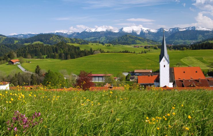
First, a short detour is worthwhile to the flood control reservoir in Stiefenhofen. It protects the village from the strongly rising creek during heavy rainfall. From there, the tour passes the distinctive meeting center built of domestic silver fir towards Ranzenried. Here, the view opens onto the mountain range 'Nagelfluhkette' with the 1833 meters high mountain 'Hochgrat'. The hiking tour leads you along the edge of the forest towards the tourist village called 'Wolfsried'. Be carful when crossing the main street at the parking space. Passing three seperately situated farms, the tour goes on to a former mill called 'Weißenbachmühle. Already in 1290, there has been a farm here. The old evidence of a mill at this place can be traced back to the year 1579. Grain was milled to the yer 1876 in the 'Weißenbachmühle'. The saw mill has been active much longer.
Upper Argen
The well of the Upper Argen is also at this place: the confluence of the creeks Tannholzbach and Seelesgraben, Schwarzenbach and Trabersbach (Weißenbach) create the Upper Argen. Since 1854, a railway has forced its way through the narrow valley alongside the creek 'Wildbach'. In former times, there was a meal and saw mill at the end of the valley. In the village Oberthal, there is also a former saw mill. There are still some gang saws driven by hydropower. Green electricity is generated by a small modern hydraulic power station. The Upper Argen meanders between the villages Oberthalhofen and Unterthalhofen through farmed meadows. In Unterthalhofen there is a still intact and active saw mill, where timber is cut. At the same time, two turbines generate electricity from hydropower. Through the village Harbatshofen and the forest 'Burgkristallwald' the tour takes you back to Stiefenhofen.
Parking – village well – flood control reservoir – meeting center – Ranzenried – tourist village Wolfsried – Weißenbachmühle – Oberthalhofen – Unterthalhofen – Harbatshofen – Stiefenhofen
A leisurely round tour without difficulties. The tour runs on filed paths and asphalted side roads.
Ähnliche Touren
- Wandertour
"Gutes vom Dorf" - Culinary hike through Ofterschwang
Tradition, untouched landscape and a lot of regional delicacies - that is what distinguishes Ofterschwang.
mehr dazuDistanz 11,8 km Dauer 3:30 h Aufstieg 309 m Schwierigkeit mittel - Wandertour
"Himmelstürmer"-Trail
© Allgäu GmbH
The "Himmelsstürmer"-Route consists of 24 stage (not counting access routes) and is 342 km long.
mehr dazuDistanz 432,5 km Dauer 148:35 h Aufstieg 17.980 m Schwierigkeit schwer - Wandertour
"Wasserläufer"-Trail
© Allgäu GmbH
The "Wasserläufer"-Route consists of 26 stages (not counting access routes) and is 384 km long.
mehr dazuDistanz 381,6 km Dauer 110:10 h Aufstieg 11.237 m Schwierigkeit schwer - Wandertour
"Wiesengänger"-Trail
© Allgäu GmbH
The "Wasserläufer"-Route takes you through a beautiful hilly landscape on 463 km.
mehr dazuDistanz 424,8 km Dauer 107:30 h Aufstieg 5.300 m Schwierigkeit mittel - Wandertour
Alp hike Söllereck - Riezlern
© Kleinwalsertal Tourismus eGen
Söllereckbahn - Alpe Schrattenwang - Mittelalp - Bergstüble - Westeggtobel - Riezlern.
mehr dazuDistanz 5,6 km Dauer 2:25 h Aufstieg 51 m Schwierigkeit leicht - Wandertour
Alpine Meadows - hiking tour from Ofterschwang
Varied and cozy through forests and over meadows. Great views, varied nature and small playgrounds along the way with refreshments.
mehr dazuDistanz 8,3 km Dauer 3:00 h Aufstieg 427 m Schwierigkeit mittel - Wandertour
Around the lake Schwansee (swan lake) in the Schwansee park
hike around the lake Schwansee
duration: 1 hour
length: 2 kilometers
mehr dazuDistanz 3,2 km Dauer 1:30 h Aufstieg 29 m Schwierigkeit leicht - Wandertour
Border guard trail Oberreute/Allgaeu
Cross-border experience path for the whole family.
mehr dazuDistanz 9,1 km Dauer 2:30 h Aufstieg 173 m Schwierigkeit mittel - Wandertour
Bridge building river Leiblach: Hiking along the border river - Waterway no.30 in the Western Allgaeu
© Thomas Gretler
Tour no.30 of the waterways in the Western Allgaeu invites you to a cross-border expedition into the valley of the river Leiblach. According to the motto "bridge building".
mehr dazuDistanz 11,5 km Dauer 3:50 h Aufstieg 207 m Schwierigkeit leicht - Wandertour
Bridge building river Leiblach: Hiking along the border river - Waterway no.31 in the Western Allgaeu
Three tours of the waterways of the Western Allgaeu (29,30 and 31) invite you to a cross-border discovery journey to the valley of the Leiblach. According to the motto 'building bridges'. The valley's lifeline is the river Leiblach, a near-natural river of the low...
mehr dazuDistanz 21,5 km Dauer 6:20 h Aufstieg 539 m Schwierigkeit schwer


Die Inhalte dieser Seite werden in Kooperation mit Outdooractive bereitgestellt.