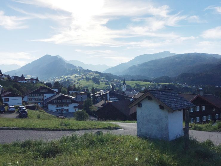
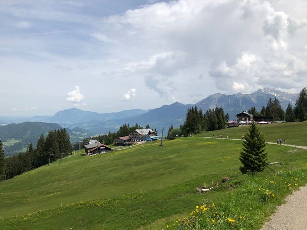
Söllereckbahn - Alpe Schrattenwang - Mittelalp - Bergstüble - Westeggtobel - Riezlern.
Kleinwalsertal Tourismus eGen
- Strecke5,58 km
- Dauer2:25 h
- Aufstieg51 Hm
- Abstieg315 Hm
- Schwierigkeitleicht
Höhenprofil
After driveway with the Söllereckbahn begins the wonderfully landscaped lookout way to Riezlern. After a few minutes walk to reach the Schrattenwangalpe the highest point and shortly there after the state border. On the way you have a wonderful view of the imposing summit of the High Ifen (2,230 m) and the Gottesacker Plateau. An excellent refreshment stop is the GenussHütte Mittelalp. After crossing the Westeggtobel you reach with beautiful views of the valley the village Riezlern. Recommended in the afternoon with pleasant sunshine. Ascent with guest card reduced, bus in German territory (from Walserschanz) fee.
Anfahrt
Most routes from Germany lead to Ulm before carrying on along the A7. Take the Allgäu junction over a section of the A980 to the Waltenhofen junction, then take the 4- lane B19 via Sonthofen and Oberstdorf to Kleinwalsertal. From Austria (Vorarlberg) and Switzerland you reach the Kleinwalsertal via the Bregenzerwald (Hittisau) – Riedbergpass – Fischen – Oberstdorf. From Tyrol the fastest route is over the A7 to Kempten carrying on along the B19 direction Oberstdorf. A motorway vignette is not required to reach the valley.Parken
A parking area (fee required) is located directly by the starting point.Öffentliche Verkehrsmittel
Leave the car where it is!The Walserbus is a convenient way to reach your starting point. Line 1 takes you to the town Oberstdorf. For this tour you need to get off at the bus stop "Söllereckbahn". Way back: bus line 1 from "Riezlern Post".
EMERGENCY:
140 Alpine Emergencies Austria wide
144 Alpine Emergencies Vorarlberg
112 Euro-Emergencies (works with every mobile network)
www.vorarlberg.travel/sicherheitstipps
140 Alpine Emergencies Austria wide
144 Alpine Emergencies Vorarlberg
112 Euro-Emergencies (works with every mobile network)
www.vorarlberg.travel/sicherheitstipps
Sturdy shoes and hiking poles for steep sections recommended. When necessary, rainproof clothing and head covering.
Ähnliche Touren
- Wandertour
Around the lake Schwansee (swan lake) in the Schwansee park
© Tourist Information Schwangau
hike around the lake Schwansee
duration: 1 hour
length: 2 kilometers
mehr dazuDistanz 3,2 km Dauer 1:30 h Aufstieg 29 m Schwierigkeit leicht - Wandertour
Bridge building river Leiblach: Hiking along the border river - Waterway no.30 in the Western Allgaeu
© Thomas Gretler
Tour no.30 of the waterways in the Western Allgaeu invites you to a cross-border expedition into the valley of the river Leiblach. According to the motto "bridge building".
mehr dazuDistanz 11,5 km Dauer 3:50 h Aufstieg 207 m Schwierigkeit leicht - Wandertour
Bridge building river Leiblach: Hiking along the border river - Waterways in the Western Allgaeu
© Thomas Gretler
Three tours of the waterways of the Western Allgaeu (29,30 and 31) invite you to a cross-border discovery journey to the valley of the Leiblach. According to the motto 'building bridges'. The valley's lifeline is the river Leiblach, a near-natural river of the low...
mehr dazuDistanz 7,6 km Dauer 2:00 h Aufstieg 99 m Schwierigkeit leicht - Wandertour
Golfplatztour – Rundwanderung durch die Hörnerdörfer
Golfplatztour – Rundwanderung durch die Hörnerdörfer
mehr dazuDistanz 11,3 km Dauer 3:04 h Aufstieg 168 m Schwierigkeit leicht - Wandertour
Hike from Ofterschwang to Wittelsbacher Höhe
A varied circular route from Ofterschwang to the Wittelsbacher Höhe near Schweineberg over meadows and through forests and with fantastic views.
mehr dazuDistanz 6,1 km Dauer 2:00 h Aufstieg 127 m Schwierigkeit leicht - Wandertour
Moosrundweg - walk around the Tiefenberger bog near Ofterschwang
Family-friendly circular route through the ancient and idyllic bog.
mehr dazuDistanz 6,7 km Dauer 2:00 h Aufstieg 63 m Schwierigkeit leicht - Wandertour
Nature Trail - Ofterschwang
With information signs and stations on the natural development and cultivation of the cultural landscape.
mehr dazuDistanz 6,2 km Dauer 2:00 h Aufstieg 153 m Schwierigkeit leicht - Wandertour
Oberreute: Upper "Hausbachklamm"
© Landratsamt Lindau (Bodensee)
Oberreute: Upper "Hausbachklamm"
mehr dazuDistanz 4,4 km Dauer 1:15 h Aufstieg 52 m Schwierigkeit leicht - Wandertour
Ofterschwanger Horn - a comfortable walk round the peak
A nice and easy walk with great views of the Alps at Oberstdorf.
(suiteable for prams)
mehr dazuDistanz 2,4 km Dauer 1:00 h Aufstieg 70 m Schwierigkeit leicht - Wandertour
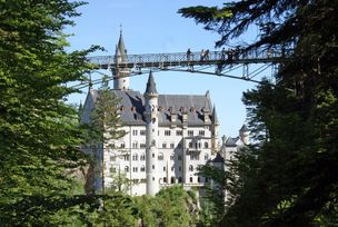
Walk to Neuschwanstein castle
© Outdooractive Editors
Hohenschwangau car park P1-P4 - Ticket Centre - Neuschwansteinstraße - Neuschwanstein Castle - Marienbrücke (closed until approx. autumn 2022) - Neuschwansteinstraße - car park
mehr dazuDistanz 1,9 km Dauer 0:43 h Aufstieg 147 m Schwierigkeit leicht


Kleinwalsertal Tourismus eGen
Kleinwalsertal Tourismus eGen

Kleinwalsertal Tourismus eGen
Kleinwalsertal Tourismus eGen
Kleinwalsertal Tourismus eGen

Kleinwalsertal Tourismus eGen
Die Inhalte dieser Seite werden in Kooperation mit Outdooractive bereitgestellt.