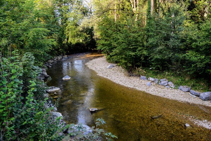
Tour no. 30 of the waterways in the Western Allgaeu invites you to a cross-border expedition into the valley of the river Leiblach. According to the motto "bridge building".
Thomas Gretler
- Strecke11,47 km
- Dauer3:50 h
- Aufstieg207 Hm
- Abstieg207 Hm
- Schwierigkeitleicht
Höhenprofil
The river Leiblach, a semi-natural mid-sized mountain stream that mounds into Lake Constance between Lindau and Hoerbranz, is the valley's lifeline. In its underflow, the river marks the border between Germany and Austria. Enchanted ravine creeks, shady ravine forests, gushing waterfalls and fantastic views are waiting for hikers. Again and again, gravel banks and flat water areas are inviting the hikers to reat and have a picnic. In Bad Diezlings (Austria) the restaurant of the same name is located. In this restaurant, the world-famous writer Norbert Jacques wrote his novel "Dr. Mabuse the Gambler" in 1920. The Kneipp facility in Hörbranz provides a pleasant cooling from the point of view of health. The pond "Diezlinger Teich" is the livng space of a multitude of animals and plants. In the convent "Maria Stern" in Gwiggen there is a priory shop worth seeing. Hikers are esteemed guests on the adjoining terrace.
The diverse hiking tour runs on forest and meadow paths and lasts half a day. Some short sections of the path are asphalted. Descending to the river Leiblach and ascending to the Convent Gwiggen several altitude metres have to be covered.
Ähnliche Touren
- Wandertour
Around the lake Schwansee (swan lake) in the Schwansee park
hike around the lake Schwansee
duration: 1 hour
length: 2 kilometers
mehr dazuDistanz 3,2 km Dauer 1:30 h Aufstieg 29 m Schwierigkeit leicht - Wandertour
Bridge building river Leiblach: Hiking along the border river - Waterways in the Western Allgaeu
© Thomas Gretler
Three tours of the waterways of the Western Allgaeu (29,30 and 31) invite you to a cross-border discovery journey to the valley of the Leiblach. According to the motto 'building bridges'. The valley's lifeline is the river Leiblach, a near-natural river of the low...
mehr dazuDistanz 7,6 km Dauer 2:00 h Aufstieg 99 m Schwierigkeit leicht - Wandertour
Golfplatztour – Rundwanderung durch die Hörnerdörfer
Golfplatztour – Rundwanderung durch die Hörnerdörfer
mehr dazuDistanz 11,3 km Dauer 3:04 h Aufstieg 168 m Schwierigkeit leicht - Wandertour
Hike from Ofterschwang to Wittelsbacher Höhe
A varied circular route from Ofterschwang to the Wittelsbacher Höhe near Schweineberg over meadows and through forests and with fantastic views.
mehr dazuDistanz 6,1 km Dauer 2:00 h Aufstieg 127 m Schwierigkeit leicht - Wandertour
Moosrundweg - walk around the Tiefenberger bog near Ofterschwang
Family-friendly circular route through the ancient and idyllic bog.
mehr dazuDistanz 6,7 km Dauer 2:00 h Aufstieg 63 m Schwierigkeit leicht - Wandertour
Nature Trail - Ofterschwang
With information signs and stations on the natural development and cultivation of the cultural landscape.
mehr dazuDistanz 6,2 km Dauer 2:00 h Aufstieg 153 m Schwierigkeit leicht - Wandertour
Oberreute: Upper "Hausbachklamm"
Oberreute: Upper "Hausbachklamm"
mehr dazuDistanz 4,4 km Dauer 1:15 h Aufstieg 52 m Schwierigkeit leicht - Wandertour
Ofterschwanger Horn - a comfortable walk round the peak
A nice and easy walk with great views of the Alps at Oberstdorf.
(suiteable for prams)
mehr dazuDistanz 2,4 km Dauer 1:00 h Aufstieg 70 m Schwierigkeit leicht - Wandertour
Walk to Neuschwanstein castle
Hohenschwangau car park P1-P4 - Ticket Centre - Neuschwansteinstraße - Neuschwanstein Castle - Marienbrücke (closed until approx. autumn 2022) - Neuschwansteinstraße - car park
mehr dazuDistanz 1,9 km Dauer 0:43 h Aufstieg 147 m Schwierigkeit leicht - Wandertour
Wittelsbacher hiking trail from Ofterschwang via Schweineberg
Beautiful circular route over the village of Westerhofen, the Wittelsbacher Höhe with a magnificent view into the Iller Valley and the Oberstdorfer mountains as well as Schweineberg with the mountain cheese dairy.
mehr dazuDistanz 6,5 km Dauer 2:30 h Aufstieg 175 m Schwierigkeit leicht


Die Inhalte dieser Seite werden in Kooperation mit Outdooractive bereitgestellt.