Two of the most attractive natural beauties of the Western Allgaeu can be seen at this tranquil half a day hike around Hergatz and Hegensweiler and Opfenbach: the two nature reserves Degermoos and Stockenweiler Weiher enjoy the highest level of protection nowadays.
- Strecke21,70 km
- Dauer4:30 h
- Aufstieg162 Hm
- Abstieg163 Hm
- Schwierigkeit-
Höhenprofil
Kleyenmühle
Coming from Opfenbach, the tour leads you through the village Goeritz and initially to Obernuetzenbrugg. Here, it is worthwhile to visit the former meal mill, saw mill and brickyard Kleyenmuehle which is located at the Leiblach. It has been mentioned in a document, already in 1650. Even today, a nearby small power station generates electricity from hydropower.
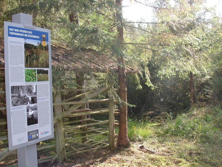
Degermoos und Stockenweiler Weiher
After crossing the main road it is worthwhile to take a trip towards the village Adelgunz. In the mossland Degermoos you can watch a former peat-ditch and you will learn many things about the history of peat cutting in the moor. In the 19th century, for example, rails have been laid into the moorland, in order to transport the freshly cut peat directly to the train station of Hergatz. The peat was stored and dried there before it was used for the heating of the steam engines of the southern runway. Hiking through Volklings you reach the Stockenweiler Weiher, protected since 1984. In the 15th century, already, the Heilig-Geist-Spital (Hospice of the Holy Spirit) has damed it to breed carps and pikes. The fish ended up on the menu of the hospice's patients as a welcome change. Today, the pond is an important place of nesting and stopover for partly rare water birds. That's why just allowed to swim in the pond's front area.
Bruggmühle
From Stockenweiler via Beuren, the hiking tour leads you along the Leiblach to Ruhlands. A short distance off the path there is the Bruggmuehle which has been mentioned in records in 1269. The meal mill has been operating until 1958 and the saw mill ist still operating.
Parking in Opfenbach – Göritz – Kleyenmühle – Obernützenbrugg – Naturschutzgebiet Degermoos – Volklings – Nature reserve Stockenweiler Weiher – Stockenweiler – Leiblachwanderweg (hiking trail near the Leiblach) – Beuren – Bruggmühle – Ruhlands – Parking in Opfenbach
Simple half day hike without larger increases and partly on forest paths, partly on asphalted side roads.
Ähnliche Touren
- Wandertour
"Gutes vom Dorf" - Culinary hike through Ofterschwang
Tradition, untouched landscape and a lot of regional delicacies - that is what distinguishes Ofterschwang.
mehr dazuDistanz 11,8 km Dauer 3:30 h Aufstieg 309 m Schwierigkeit mittel - Wandertour
"Himmelstürmer"-Trail
© Allgäu GmbH
The "Himmelsstürmer"-Route consists of 24 stage (not counting access routes) and is 342 km long.
mehr dazuDistanz 432,5 km Dauer 148:35 h Aufstieg 17.980 m Schwierigkeit schwer - Wandertour
"Wasserläufer"-Trail
© Allgäu GmbH
The "Wasserläufer"-Route consists of 26 stages (not counting access routes) and is 384 km long.
mehr dazuDistanz 381,6 km Dauer 110:10 h Aufstieg 11.237 m Schwierigkeit schwer - Wandertour
"Wiesengänger"-Trail
© Allgäu GmbH
The "Wasserläufer"-Route takes you through a beautiful hilly landscape on 463 km.
mehr dazuDistanz 424,8 km Dauer 107:30 h Aufstieg 5.300 m Schwierigkeit mittel - Wandertour
Alp hike Söllereck - Riezlern
© Kleinwalsertal Tourismus eGen
Söllereckbahn - Alpe Schrattenwang - Mittelalp - Bergstüble - Westeggtobel - Riezlern.
mehr dazuDistanz 5,6 km Dauer 2:25 h Aufstieg 51 m Schwierigkeit leicht - Wandertour
Alpine Meadows - hiking tour from Ofterschwang
Varied and cozy through forests and over meadows. Great views, varied nature and small playgrounds along the way with refreshments.
mehr dazuDistanz 8,3 km Dauer 3:00 h Aufstieg 427 m Schwierigkeit mittel - Wandertour
Around the lake Schwansee (swan lake) in the Schwansee park
hike around the lake Schwansee
duration: 1 hour
length: 2 kilometers
mehr dazuDistanz 3,2 km Dauer 1:30 h Aufstieg 29 m Schwierigkeit leicht - Wandertour
Border guard trail Oberreute/Allgaeu
Cross-border experience path for the whole family.
mehr dazuDistanz 9,1 km Dauer 2:30 h Aufstieg 173 m Schwierigkeit mittel - Wandertour
Bridge building river Leiblach: Hiking along the border river - Waterway no.30 in the Western Allgaeu
© Thomas Gretler
Tour no.30 of the waterways in the Western Allgaeu invites you to a cross-border expedition into the valley of the river Leiblach. According to the motto "bridge building".
mehr dazuDistanz 11,5 km Dauer 3:50 h Aufstieg 207 m Schwierigkeit leicht - Wandertour
Bridge building river Leiblach: Hiking along the border river - Waterway no.31 in the Western Allgaeu
Three tours of the waterways of the Western Allgaeu (29,30 and 31) invite you to a cross-border discovery journey to the valley of the Leiblach. According to the motto 'building bridges'. The valley's lifeline is the river Leiblach, a near-natural river of the low...
mehr dazuDistanz 21,5 km Dauer 6:20 h Aufstieg 539 m Schwierigkeit schwer


Die Inhalte dieser Seite werden in Kooperation mit Outdooractive bereitgestellt.