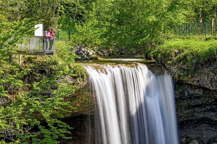
The "Scheidegger Wasserfälle" (Scheidegg cascades) rank among the 100 most beautiful geotopes and are a great destination for families with children. The impressive natural spectacle of the cascades, the big water playground and interesting information about age-old water techniques leave no room for boredom.
Landratsamt Lindau (Bodensee)
- Strecke6,98 km
- Dauer1:45 h
- Aufstieg137 Hm
- Abstieg137 Hm
- Schwierigkeit-
Höhenprofil
Scheidegger Wasserfälle (Scheidegg Cascades)
The water of the creek Rickenbach is tumbling down at the "Scheidegger Wasserfälle" via two mighty ridgelines: the two cascades lying close together 18 respectively 22 meters high and can be watched from several view points. Coming down from the cascades the view opens to the Rohrach ravine. A ravine that is carved up to 200 meters and is the biggest nature reserve in the district of Lindau with a special protection status.
Fountains
Children will have fun at the petting zoo and the newly created water playground above the cascades: here they can build dams, gaze at a water wheel or just splash around in the water at their heart's content. The information concerning water transport with a hydraulic ram are rather meant for the adult visitors. The old and almost forgotten technique was revived at the Scheidegg cascades and supplies the devices at the playground with water.
Variants tour no.1 and no.2
Whoever wants to combine a visit of the Scheidegg cascades with a round tour can choose between two tours: Hiking to the "Hasenreuter Wasserfall" (tour no.1) you can admire another cascade worth visiting and the tour to the lake "Waldsee" (tour no.2) invites you to have a bath in the moor lake and visit the reptile zoo.
Parking space cheidegger Wasserfälle – Rickenbach – Aizenreute – Hasenreuter Wasserfälle – Scheidegg-Ort – Rickenbach – parking space
Anyone climbing downto the second cascade has to master 200 steps. The cascades can be viewed perfectly from above. The two round tours runs on forest paths that are predominatly well passable.
Ähnliche Touren
- Wandertour
"Gutes vom Dorf" - Culinary hike through Ofterschwang
Tradition, untouched landscape and a lot of regional delicacies - that is what distinguishes Ofterschwang.
mehr dazuDistanz 11,8 km Dauer 3:30 h Aufstieg 309 m Schwierigkeit mittel - Wandertour
"Himmelstürmer"-Trail
© Allgäu GmbH
The "Himmelsstürmer"-Route consists of 24 stage (not counting access routes) and is 342 km long.
mehr dazuDistanz 432,5 km Dauer 148:35 h Aufstieg 17.980 m Schwierigkeit schwer - Wandertour
"Wasserläufer"-Trail
© Allgäu GmbH
The "Wasserläufer"-Route consists of 26 stages (not counting access routes) and is 384 km long.
mehr dazuDistanz 381,6 km Dauer 110:10 h Aufstieg 11.237 m Schwierigkeit schwer - Wandertour
"Wiesengänger"-Trail
© Allgäu GmbH
The "Wasserläufer"-Route takes you through a beautiful hilly landscape on 463 km.
mehr dazuDistanz 424,8 km Dauer 107:30 h Aufstieg 5.300 m Schwierigkeit mittel - Wandertour
Alp hike Söllereck - Riezlern
© Kleinwalsertal Tourismus eGen
Söllereckbahn - Alpe Schrattenwang - Mittelalp - Bergstüble - Westeggtobel - Riezlern.
mehr dazuDistanz 5,6 km Dauer 2:25 h Aufstieg 51 m Schwierigkeit leicht - Wandertour
Alpine Meadows - hiking tour from Ofterschwang
Varied and cozy through forests and over meadows. Great views, varied nature and small playgrounds along the way with refreshments.
mehr dazuDistanz 8,3 km Dauer 3:00 h Aufstieg 427 m Schwierigkeit mittel - Wandertour
Around the lake Schwansee (swan lake) in the Schwansee park
hike around the lake Schwansee
duration: 1 hour
length: 2 kilometers
mehr dazuDistanz 3,2 km Dauer 1:30 h Aufstieg 29 m Schwierigkeit leicht - Wandertour
Border guard trail Oberreute/Allgaeu
Cross-border experience path for the whole family.
mehr dazuDistanz 9,1 km Dauer 2:30 h Aufstieg 173 m Schwierigkeit mittel - Wandertour
Bridge building river Leiblach: Hiking along the border river - Waterway no.30 in the Western Allgaeu
© Thomas Gretler
Tour no.30 of the waterways in the Western Allgaeu invites you to a cross-border expedition into the valley of the river Leiblach. According to the motto "bridge building".
mehr dazuDistanz 11,5 km Dauer 3:50 h Aufstieg 207 m Schwierigkeit leicht - Wandertour
Bridge building river Leiblach: Hiking along the border river - Waterway no.31 in the Western Allgaeu
Three tours of the waterways of the Western Allgaeu (29,30 and 31) invite you to a cross-border discovery journey to the valley of the Leiblach. According to the motto 'building bridges'. The valley's lifeline is the river Leiblach, a near-natural river of the low...
mehr dazuDistanz 21,5 km Dauer 6:20 h Aufstieg 539 m Schwierigkeit schwer


Die Inhalte dieser Seite werden in Kooperation mit Outdooractive bereitgestellt.