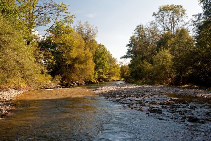
The lower Argen, same as the upper Argen, is one of the few rivers in the alpine upland that flow almost unspoilt towards the valley in large parts. On the round tour 'The lower Argen at Isny-Neutrauchburg' there are ten info stations telling you something about the river system and its livng environment.
- Strecke8,73 km
- Dauer2:30 h
- Aufstieg149 Hm
- Abstieg145 Hm
- Schwierigkeit-
Höhenprofil
Town center of Isny-Neutrauchburg - Dengeltshofen - lower Argen - Herbisweiher - Menelzhofer Berg - Peterhof - Maxbauer - Halden - Dengeltshofen - town center of Isny-Neutrauchburg
Ähnliche Touren
- Wandertour
"Gutes vom Dorf" - Culinary hike through Ofterschwang
Tradition, untouched landscape and a lot of regional delicacies - that is what distinguishes Ofterschwang.
mehr dazuDistanz 11,8 km Dauer 3:30 h Aufstieg 309 m Schwierigkeit mittel - Wandertour
"Himmelstürmer"-Trail
© Allgäu GmbH
The "Himmelsstürmer"-Route consists of 24 stage (not counting access routes) and is 342 km long.
mehr dazuDistanz 432,5 km Dauer 148:35 h Aufstieg 17.980 m Schwierigkeit schwer - Wandertour
"Wasserläufer"-Trail
© Allgäu GmbH
The "Wasserläufer"-Route consists of 26 stages (not counting access routes) and is 384 km long.
mehr dazuDistanz 381,6 km Dauer 110:10 h Aufstieg 11.237 m Schwierigkeit schwer - Wandertour
"Wiesengänger"-Trail
© Allgäu GmbH
The "Wasserläufer"-Route takes you through a beautiful hilly landscape on 463 km.
mehr dazuDistanz 424,8 km Dauer 107:30 h Aufstieg 5.300 m Schwierigkeit mittel - Wandertour
Alp hike Söllereck - Riezlern
© Kleinwalsertal Tourismus eGen
Söllereckbahn - Alpe Schrattenwang - Mittelalp - Bergstüble - Westeggtobel - Riezlern.
mehr dazuDistanz 5,6 km Dauer 2:25 h Aufstieg 51 m Schwierigkeit leicht - Wandertour
Alpine Meadows - hiking tour from Ofterschwang
Varied and cozy through forests and over meadows. Great views, varied nature and small playgrounds along the way with refreshments.
mehr dazuDistanz 8,3 km Dauer 3:00 h Aufstieg 427 m Schwierigkeit mittel - Wandertour
Around the lake Schwansee (swan lake) in the Schwansee park
hike around the lake Schwansee
duration: 1 hour
length: 2 kilometers
mehr dazuDistanz 3,2 km Dauer 1:30 h Aufstieg 29 m Schwierigkeit leicht - Wandertour
Border guard trail Oberreute/Allgaeu
Cross-border experience path for the whole family.
mehr dazuDistanz 9,1 km Dauer 2:30 h Aufstieg 173 m Schwierigkeit mittel - Wandertour
Bridge building river Leiblach: Hiking along the border river - Waterway no.30 in the Western Allgaeu
© Thomas Gretler
Tour no.30 of the waterways in the Western Allgaeu invites you to a cross-border expedition into the valley of the river Leiblach. According to the motto "bridge building".
mehr dazuDistanz 11,5 km Dauer 3:50 h Aufstieg 207 m Schwierigkeit leicht - Wandertour
Bridge building river Leiblach: Hiking along the border river - Waterway no.31 in the Western Allgaeu
Three tours of the waterways of the Western Allgaeu (29,30 and 31) invite you to a cross-border discovery journey to the valley of the Leiblach. According to the motto 'building bridges'. The valley's lifeline is the river Leiblach, a near-natural river of the low...
mehr dazuDistanz 21,5 km Dauer 6:20 h Aufstieg 539 m Schwierigkeit schwer


Die Inhalte dieser Seite werden in Kooperation mit Outdooractive bereitgestellt.