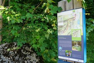
Hike from Weissensee between the Faulenbach Valley and the Tyrolean Vils Valley along hidden paths.
Füssen Tourismus und Marketing
- Strecke10,46 km
- Dauer3:45 h
- Aufstieg333 Hm
- Abstieg348 Hm
- Schwierigkeitmittel
Höhenprofil
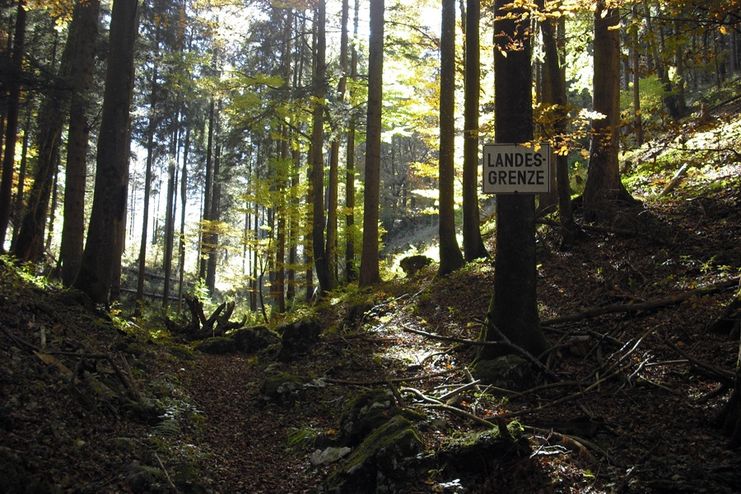
From Lake Weissensee, forest paths lead to Lake Alat, the southern shore of which used to be the quickest way to cross the green border and where some smuggled goods used to travel before the EU opened the state borders.
After rainy days, the Ländescharte can be slippery and is not recommended.
Ankle-wrapping hiking boots with good tread sole required. Hiking poles provide grip and support.
Ähnliche Touren
- Wandertour
"Wiesengänger"-Trail
© Allgäu GmbH
The "Wasserläufer"-Route takes you through a beautiful hilly landscape on 463 km.
mehr dazuDistanz 424,8 km Dauer 107:30 h Aufstieg 5.300 m Schwierigkeit mittel - Wandertour
Border guard trail Oberreute/Allgaeu
Cross-border experience path for the whole family.
mehr dazuDistanz 9,1 km Dauer 2:30 h Aufstieg 173 m Schwierigkeit mittel - Wandertour
Castle ruin Falkenstein
Castle ruin Falkenstein
mehr dazuDistanz 7,8 km Dauer 3:00 h Aufstieg 530 m Schwierigkeit mittel - Wandertour
Hiking on the ridgeway ('Hoehenweg') from Scheidegg to the mountain Pfaender - the classic
The wonderful hiking tour leads you from Scheidegg through the German-Austrian alpine upland to the mountain Pfaender heighted 1064 meters. There you will be rewarded with an impressive panoramic view.
mehr dazuDistanz 10,9 km Dauer 3:30 h Aufstieg 415 m Schwierigkeit mittel - Wandertour
Kapellenwanderung in Stiefenhofen
Kapellenwanderung in Stiefenhofen
mehr dazuDistanz 14,0 km Dauer 4:00 h Aufstieg 326 m Schwierigkeit mittel - Wandertour
Nature reserve Eistobel: Circuit via the mountain Riedholzer Kugel - Westallgäu waterway 20
Nature reserve Eistobel - Wonder world made of water, rocks and iceRushing waterfalls and deep swirl holes, huge blocks of Nagelfluh, a conglomerate of rock, sand and calcareous binders and enormous rock faces - the nature reserve Eistobel with a total length of approx....
mehr dazuDistanz 9,2 km Dauer 3:45 h Aufstieg 399 m Schwierigkeit mittel - Wandertour
Villa parks, vineyards and orchards – the Lindau garden culture trail
Villa parks, vineyards and orchards – the Lindau garden culture trail
mehr dazuDistanz 9,3 km Dauer 2:30 h Aufstieg 65 m Schwierigkeit mittel - Wandertour
Wassererlebnisweg durch den Haldertobel
Schattige Wege mit schäumenden Wasserfällen und kleinen Strudeln führen Sie auf dieser Wanderung ins idyllische Örtchen Gunzesried.
mehr dazuDistanz 7,8 km Dauer 2:25 h Aufstieg 173 m Schwierigkeit mittel - Wandertour
Alpine Meadows - hiking tour from Ofterschwang
Varied and cozy through forests and over meadows. Great views, varied nature and small playgrounds along the way with refreshments.
mehr dazuDistanz 8,3 km Dauer 3:00 h Aufstieg 427 m Schwierigkeit mittel - Wandertour
Hochwiesweg Hike
A gorgeous little loop with beautiful views.
(pram friendly tour)
mehr dazuDistanz 3,9 km Dauer 1:00 h Aufstieg 120 m Schwierigkeit mittel


Die Inhalte dieser Seite werden in Kooperation mit Outdooractive bereitgestellt.