A hike with a magnificent panorama.
- Strecke11,14 km
- Dauer4:30 h
- Aufstieg700 Hm
- Abstieg726 Hm
- Schwierigkeitmittel
Höhenprofil
There are three different alpine pastures or huts along the trail. Enjoy the peace and quiet of nature with a tasty snack, hearty home cooking or coffee and cake.
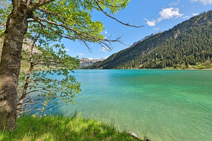
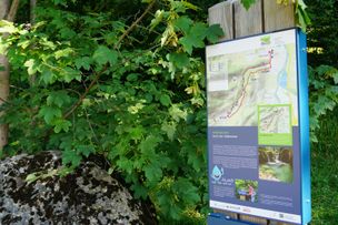
The tour starts at the paid parking lot at Haldensee. This can also be easily reached with the hiking bus. The trail leads us in the direction of Edenbachalpe/Strindenalpe through the Strindental valley with a view of the crystal-clear, green-blue shimmering Haldensee. First we reach the Edenbachalpe, behind the alpine pasture a path leads us further along the Saalfelder Höhenweg towards the upper Strindenalpe. Once there, the descent runs towards Usseralpe. On the forest path you can take a leisurely descent - take a look at the Urfall (waterfall) - and continue via the hamlets of Schmieden/Bogen to Tannheim. Or you can walk from the Usseralpe to the top station at Neunerköpfle and from there take the cable car down to the valley. (Last descent 16:15 hrs)
Anfahrt
On the motorway A7 at the exit "Oy-Mittelberg" on the B310 towards Wertach and to Oberjoch. There follow the signposting "Tannheimer Tal" B199 until Haldensee. From the Tyrolean side via Reutte on the B198 towards Lechtal until Weißenbach, over the Gaichtpass along the B199 until Haldensee.Parken
Lake car park at Haldensee - parking fee.Öffentliche Verkehrsmittel
By train to Sonthofen, Pfronten/Ried or Reutte, then by bus to Grän/Haldensee.
Generally applicable and customary rules of conduct
It should be noted that in mountaineering there is an increased risk of accidents and injuries. Despite careful route planning, a basic risk always remains. Tour preparation through endurance sports, appropriate technical training and further education as well as personal prudence reduces the danger of accidents and risks. However, please never forget that the weather in the mountains can change very quickly. Stay on the marked hiking trails.
The personal mountaineering equipment must be safe and serviceable and meet the relevant technical standards. Every hiker is recommended to obtain information about the planned tours from specialist alpine literature or on site.
Ähnliche Touren
- Wandertour
"Wiesengänger"-Trail
© Allgäu GmbH
The "Wasserläufer"-Route takes you through a beautiful hilly landscape on 463 km.
mehr dazuDistanz 424,8 km Dauer 107:30 h Aufstieg 5.300 m Schwierigkeit mittel - Wandertour
Border guard trail Oberreute/Allgaeu
Cross-border experience path for the whole family.
mehr dazuDistanz 9,1 km Dauer 2:30 h Aufstieg 173 m Schwierigkeit mittel - Wandertour
Castle ruin Falkenstein
Castle ruin Falkenstein
mehr dazuDistanz 7,8 km Dauer 3:00 h Aufstieg 530 m Schwierigkeit mittel - Wandertour
Hiking on the ridgeway ('Hoehenweg') from Scheidegg to the mountain Pfaender - the classic
The wonderful hiking tour leads you from Scheidegg through the German-Austrian alpine upland to the mountain Pfaender heighted 1064 meters. There you will be rewarded with an impressive panoramic view.
mehr dazuDistanz 10,9 km Dauer 3:30 h Aufstieg 415 m Schwierigkeit mittel - Wandertour
Kapellenwanderung in Stiefenhofen
Kapellenwanderung in Stiefenhofen
mehr dazuDistanz 14,0 km Dauer 4:00 h Aufstieg 326 m Schwierigkeit mittel - Wandertour
Nature reserve Eistobel: Circuit via the mountain Riedholzer Kugel - Westallgäu waterway 20
Nature reserve Eistobel - Wonder world made of water, rocks and iceRushing waterfalls and deep swirl holes, huge blocks of Nagelfluh, a conglomerate of rock, sand and calcareous binders and enormous rock faces - the nature reserve Eistobel with a total length of approx....
mehr dazuDistanz 9,2 km Dauer 3:45 h Aufstieg 399 m Schwierigkeit mittel - Wandertour
Villa parks, vineyards and orchards – the Lindau garden culture trail
Villa parks, vineyards and orchards – the Lindau garden culture trail
mehr dazuDistanz 9,3 km Dauer 2:30 h Aufstieg 65 m Schwierigkeit mittel - Wandertour
Wassererlebnisweg durch den Haldertobel
Schattige Wege mit schäumenden Wasserfällen und kleinen Strudeln führen Sie auf dieser Wanderung ins idyllische Örtchen Gunzesried.
mehr dazuDistanz 7,8 km Dauer 2:25 h Aufstieg 173 m Schwierigkeit mittel - Wandertour
Alpine Meadows - hiking tour from Ofterschwang
Varied and cozy through forests and over meadows. Great views, varied nature and small playgrounds along the way with refreshments.
mehr dazuDistanz 8,3 km Dauer 3:00 h Aufstieg 427 m Schwierigkeit mittel - Wandertour
Hörner Panorama Tour - lovely mountain hike from Bolsterlang or Ofterschwang
This fantastic tour can start either in Bolsterlang or Ofterschwang and takes you over the popular Hörner Panorama Tour along the Weiherkopf, Rangiswanger Horn, Sigiswanger Horn and Ofterschwanger Horn.
mehr dazuDistanz 16,3 km Dauer 7:45 h Aufstieg 1.017 m Schwierigkeit mittel


Die Inhalte dieser Seite werden in Kooperation mit Outdooractive bereitgestellt.