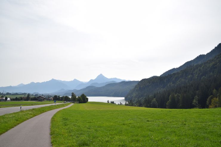
This short hike is the best way to get to know Weissensee.
Füssen Tourismus und Marketing
- Strecke4,25 km
- Dauer1:15 h
- Aufstieg83 Hm
- Abstieg83 Hm
- Schwierigkeitleicht
Höhenprofil
From the starting point at the lake Weissensee bathing area, you will hike through some idyllically situated parts of Weissensee within a short time and will always have a magnificent view over lake Weissensee to the Ammergau Alps. At the end of the tour, which is not very strenuous, you can treat yourself to a refreshing swim in Lake Weissensee or a stop at the kiosk at the bathing area.
The trail is marked throughout with the yellow pictogram of trail no. 1.
Ähnliche Touren
- Wandertour
Alp hike Söllereck - Riezlern
© Kleinwalsertal Tourismus eGen
Söllereckbahn - Alpe Schrattenwang - Mittelalp - Bergstüble - Westeggtobel - Riezlern.
mehr dazuDistanz 5,6 km Dauer 2:25 h Aufstieg 51 m Schwierigkeit leicht - Wandertour
Around the lake Schwansee (swan lake) in the Schwansee park
hike around the lake Schwansee
duration: 1 hour
length: 2 kilometers
mehr dazuDistanz 3,2 km Dauer 1:30 h Aufstieg 29 m Schwierigkeit leicht - Wandertour
Bridge building river Leiblach: Hiking along the border river - Waterway no.30 in the Western Allgaeu
© Thomas Gretler
Tour no.30 of the waterways in the Western Allgaeu invites you to a cross-border expedition into the valley of the river Leiblach. According to the motto "bridge building".
mehr dazuDistanz 11,5 km Dauer 3:50 h Aufstieg 207 m Schwierigkeit leicht - Wandertour
Bridge building river Leiblach: Hiking along the border river - Waterways in the Western Allgaeu
© Thomas Gretler
Three tours of the waterways of the Western Allgaeu (29,30 and 31) invite you to a cross-border discovery journey to the valley of the Leiblach. According to the motto 'building bridges'. The valley's lifeline is the river Leiblach, a near-natural river of the low...
mehr dazuDistanz 7,6 km Dauer 2:00 h Aufstieg 99 m Schwierigkeit leicht - Wandertour
Oberreute: Upper "Hausbachklamm"
Oberreute: Upper "Hausbachklamm"
mehr dazuDistanz 4,4 km Dauer 1:15 h Aufstieg 52 m Schwierigkeit leicht - Wandertour
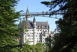
Walk to Neuschwanstein castle
Hohenschwangau car park P1-P4 - Ticket Centre - Neuschwansteinstraße - Neuschwanstein Castle - Marienbrücke (closed until approx. autumn 2022) - Neuschwansteinstraße - car park
mehr dazuDistanz 1,9 km Dauer 0:43 h Aufstieg 147 m Schwierigkeit leicht - Wandertour
Golfplatztour – Rundwanderung durch die Hörnerdörfer
Golfplatztour – Rundwanderung durch die Hörnerdörfer
mehr dazuDistanz 11,3 km Dauer 3:04 h Aufstieg 168 m Schwierigkeit leicht - Wandertour
Moosrundweg - walk around the Tiefenberger bog near Ofterschwang
Family-friendly circular route through the ancient and idyllic bog.
mehr dazuDistanz 6,7 km Dauer 2:00 h Aufstieg 63 m Schwierigkeit leicht - Wandertour
Nature Trail - Ofterschwang
With information signs and stations on the natural development and cultivation of the cultural landscape.
mehr dazuDistanz 6,2 km Dauer 2:00 h Aufstieg 153 m Schwierigkeit leicht - Wandertour
Hike from Ofterschwang to Wittelsbacher Höhe
A varied circular route from Ofterschwang to the Wittelsbacher Höhe near Schweineberg over meadows and through forests and with fantastic views.
mehr dazuDistanz 6,1 km Dauer 2:00 h Aufstieg 127 m Schwierigkeit leicht


Die Inhalte dieser Seite werden in Kooperation mit Outdooractive bereitgestellt.