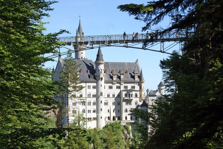
Hohenschwangau car park P1-P4 - Ticket Centre - Neuschwansteinstraße - Neuschwanstein Castle - Marienbrücke (closed until approx. autumn 2022) - Neuschwansteinstraße - car park.
- Strecke1,93 km
- Aufstieg147 Hm
- Abstieg6 Hm
- Schwierigkeitleicht
Höhenprofil
Short, easy hike to the castle of the fairytale king Ludwig II.
The starting point is the car park or the Hohenschwangau bus stop, where you can also buy tickets for Neuschwanstein and Hohenschwangau castles at the ticket centre. The castle is reached after about 40 minutes on Neuschwansteinstraße. Please note: Please arrive on time as the tickets are only valid for a timed tour. At the castle, you can first visit the inner courtyard and admire the landscape on the Zimmermannsplatz to the left. After the tour, it is definitely worth making a detour to the Marienbrücke bridge with its magnificent view. Return to the car park along the same route. You can also travel there and back in comfort by coach or shuttle bus.
Anfahrt
Coming from the B17, turn off at Hohenschwangau (royal castles)Parken
Car parks in Hohenschwangau P1-P4Öffentliche Verkehrsmittel
Hohenschwangau bus stopTickets are only available at the Ticket Centre Hohenschwangau!
Ähnliche Touren
- Wandertour
Alp hike Söllereck - Riezlern
© Kleinwalsertal Tourismus eGen
Söllereckbahn - Alpe Schrattenwang - Mittelalp - Bergstüble - Westeggtobel - Riezlern.
mehr dazuDistanz 5,6 km Dauer 2:25 h Aufstieg 51 m Schwierigkeit leicht - Wandertour
Around the lake Schwansee (swan lake) in the Schwansee park
hike around the lake Schwansee
duration: 1 hour
length: 2 kilometers
mehr dazuDistanz 3,2 km Dauer 1:30 h Aufstieg 29 m Schwierigkeit leicht - Wandertour
Bridge building river Leiblach: Hiking along the border river - Waterway no.30 in the Western Allgaeu
© Thomas Gretler
Tour no.30 of the waterways in the Western Allgaeu invites you to a cross-border expedition into the valley of the river Leiblach. According to the motto "bridge building".
mehr dazuDistanz 11,5 km Dauer 3:50 h Aufstieg 207 m Schwierigkeit leicht - Wandertour
Bridge building river Leiblach: Hiking along the border river - Waterways in the Western Allgaeu
© Thomas Gretler
Three tours of the waterways of the Western Allgaeu (29,30 and 31) invite you to a cross-border discovery journey to the valley of the Leiblach. According to the motto 'building bridges'. The valley's lifeline is the river Leiblach, a near-natural river of the low...
mehr dazuDistanz 7,6 km Dauer 2:00 h Aufstieg 99 m Schwierigkeit leicht - Wandertour
Golfplatztour – Rundwanderung durch die Hörnerdörfer
Golfplatztour – Rundwanderung durch die Hörnerdörfer
mehr dazuDistanz 11,3 km Dauer 3:04 h Aufstieg 168 m Schwierigkeit leicht - Wandertour
Hike from Ofterschwang to Wittelsbacher Höhe
A varied circular route from Ofterschwang to the Wittelsbacher Höhe near Schweineberg over meadows and through forests and with fantastic views.
mehr dazuDistanz 6,1 km Dauer 2:00 h Aufstieg 127 m Schwierigkeit leicht - Wandertour
Moosrundweg - walk around the Tiefenberger bog near Ofterschwang
Family-friendly circular route through the ancient and idyllic bog.
mehr dazuDistanz 6,7 km Dauer 2:00 h Aufstieg 63 m Schwierigkeit leicht - Wandertour
Nature Trail - Ofterschwang
With information signs and stations on the natural development and cultivation of the cultural landscape.
mehr dazuDistanz 6,2 km Dauer 2:00 h Aufstieg 153 m Schwierigkeit leicht - Wandertour
Oberreute: Upper "Hausbachklamm"
Oberreute: Upper "Hausbachklamm"
mehr dazuDistanz 4,4 km Dauer 1:15 h Aufstieg 52 m Schwierigkeit leicht - Wandertour
Ofterschwanger Horn - a comfortable walk round the peak
A nice and easy walk with great views of the Alps at Oberstdorf.
(suiteable for prams)
mehr dazuDistanz 2,4 km Dauer 1:00 h Aufstieg 70 m Schwierigkeit leicht


Die Inhalte dieser Seite werden in Kooperation mit Outdooractive bereitgestellt.