Varied little hike over narrow forest paths - with two bathing lakes to cool off.
Füssen Tourismus und Marketing
- Strecke8,46 km
- Dauer3:00 h
- Aufstieg160 Hm
- Abstieg160 Hm
- Schwierigkeitleicht
Höhenprofil
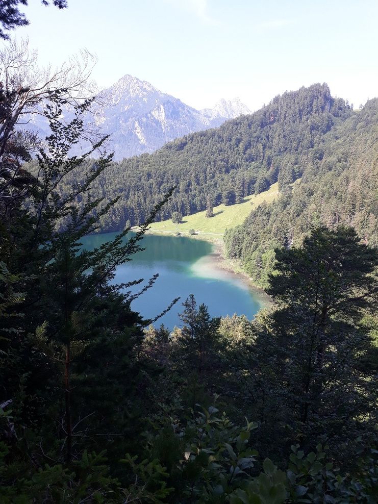
The southern Weissense circular trail narrows in places to a narrow path directly along the water and leads through a natural rock gate. Just past the substation, the route winds up the Burkenbichl mountain in condition-demanding switchbacks. At its western point, you'll have a two-lake view of lake Weissensee and lake Alatsee, as well as the mountain peaks south of the valley of Vils. Treat yourself to some time out on one of the resting benches - here you are very far away from everyday life. The lake Alatsee offers natural bathing spots and a place to stop for refreshments at the Hotel & Restaurant Alatsee. After the descent through the forest above the lake Weißensee, you can jump into the lake again at the end of the tour in the lake Weißensee.
Although it is only a short hike, we recommend bringing hiking poles.
Ähnliche Touren
- Wandertour
Alp hike Söllereck - Riezlern
© Kleinwalsertal Tourismus eGen
Söllereckbahn - Alpe Schrattenwang - Mittelalp - Bergstüble - Westeggtobel - Riezlern.
mehr dazuDistanz 5,6 km Dauer 2:25 h Aufstieg 51 m Schwierigkeit leicht - Wandertour
Around the lake Schwansee (swan lake) in the Schwansee park
hike around the lake Schwansee
duration: 1 hour
length: 2 kilometers
mehr dazuDistanz 3,2 km Dauer 1:30 h Aufstieg 29 m Schwierigkeit leicht - Wandertour
Bridge building river Leiblach: Hiking along the border river - Waterway no.30 in the Western Allgaeu
© Thomas Gretler
Tour no.30 of the waterways in the Western Allgaeu invites you to a cross-border expedition into the valley of the river Leiblach. According to the motto "bridge building".
mehr dazuDistanz 11,5 km Dauer 3:50 h Aufstieg 207 m Schwierigkeit leicht - Wandertour
Bridge building river Leiblach: Hiking along the border river - Waterways in the Western Allgaeu
© Thomas Gretler
Three tours of the waterways of the Western Allgaeu (29,30 and 31) invite you to a cross-border discovery journey to the valley of the Leiblach. According to the motto 'building bridges'. The valley's lifeline is the river Leiblach, a near-natural river of the low...
mehr dazuDistanz 7,6 km Dauer 2:00 h Aufstieg 99 m Schwierigkeit leicht - Wandertour
Golfplatztour – Rundwanderung durch die Hörnerdörfer
Golfplatztour – Rundwanderung durch die Hörnerdörfer
mehr dazuDistanz 11,3 km Dauer 3:04 h Aufstieg 168 m Schwierigkeit leicht - Wandertour
Hike from Ofterschwang to Wittelsbacher Höhe
A varied circular route from Ofterschwang to the Wittelsbacher Höhe near Schweineberg over meadows and through forests and with fantastic views.
mehr dazuDistanz 6,1 km Dauer 2:00 h Aufstieg 127 m Schwierigkeit leicht - Wandertour
Moosrundweg - walk around the Tiefenberger bog near Ofterschwang
Family-friendly circular route through the ancient and idyllic bog.
mehr dazuDistanz 6,7 km Dauer 2:00 h Aufstieg 63 m Schwierigkeit leicht - Wandertour
Nature Trail - Ofterschwang
With information signs and stations on the natural development and cultivation of the cultural landscape.
mehr dazuDistanz 6,2 km Dauer 2:00 h Aufstieg 153 m Schwierigkeit leicht - Wandertour
Oberreute: Upper "Hausbachklamm"
Oberreute: Upper "Hausbachklamm"
mehr dazuDistanz 4,4 km Dauer 1:15 h Aufstieg 52 m Schwierigkeit leicht - Wandertour
Ofterschwanger Horn - a comfortable walk round the peak
A nice and easy walk with great views of the Alps at Oberstdorf.
(suiteable for prams)
mehr dazuDistanz 2,4 km Dauer 1:00 h Aufstieg 70 m Schwierigkeit leicht


Die Inhalte dieser Seite werden in Kooperation mit Outdooractive bereitgestellt.