Along the route, eight stations with representations of the most important prayer elements invite you to contemplate and meditate. The creator of the pictures, which are embedded in granite blocks about the height of a man, is Dr.
- Strecke4,94 km
- Dauer1:17 h
- Aufstieg75 Hm
- Abstieg75 Hm
- Schwierigkeitleicht
Höhenprofil
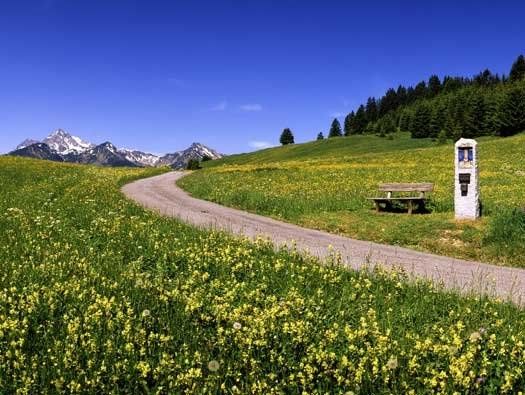
On the occasion of the 200-year-old vow of the Sacred Heart with which the Tyroleans celebrated their victory over Napoleon, the parish of Grän in the Tannheimer Tal created a path of inner reflection in 1996. This path combines meditation, art and nature in a special way. Since then numerous walkers and hikers have walked the more than one kilometre long "Father our Way" from St. Michael's Chapel in Lumberg in the direction of Tannheim Path No. 1.
Along the route, eight stations with representations of the most important prayer elements invite you to contemplate and meditate. The creator of the pictures, which are embedded in roughly man-high granite blocks, is Dr. Walter Besler from Zöblen.
"My aim was above all to motivate people to think", says Besler. The "Father our way", from which a wonderful view over the valley opens up, offers the necessary peace and quiet and surroundings for this. The result is a composition that contains numerous Christian symbols such as the burning thorn bush, but also shows the work for the daily bread as well as God's children of different skin colour. A walk on the "Vater unser Weg" (Our Father Our Way) inspired the Ostdorf lyricist Helmut Hauser to create a cantata, which was set to music by the composer Roberg Pappert and premiered in Beuron Monastery in 1999.
From the parking lot you walk across the field to the district Neu Grän. At the end of the houses turn left. Slightly downhill to the main road. Cross the road and turn left again. At the bus stop turn right. From here slightly downhill to the first crossroads, then right over the bridge and behind it left over the small ditch. Now you cross a field until you reach the asphalt road. Here turn right and after a few meters right again. After about 200m follow the signs to the left. A slight incline leads to the beginning of the Vater unser Weg. Here you can find information brochures about the theme trail. At the end of the path a gravel path leads down to the parallel field path. Here turn left until you reach the asphalt road. Continue to the right until you reach the crossroads and then turn left downhill. It is not far to the bridge over the stream. Cross the bridge and then turn right. At the next crossroads turn left into the village of Grän. Another short stretch slightly uphill and you have reached the starting point again.
Anfahrt
On the motorway A7 at the exit "Oy-Mittelberg" on the B310 towards Wertach and to Oberjoch. There follow the signposting "Tannheimer Tal" B199, exit Grän, direction Füssener Jöchle Bergbahn.From the Tyrolean side via Reutte on the B198 in the direction of Lechtal to Weißenbach, over the Gaichtpass along the B199 to the exit Grän, direction Füssener Jöchle Bergbahn.Parken
At the car park in the direction of Füssener Jöchle Bergbahn, between Burgschenke and Hotel Sonnenhof.Öffentliche Verkehrsmittel
By train to Sonthofen, Pfronten/Ried or Reutte, then by bus to Grän.Summer hiking:
No special safety instructions to be observed. You may need sun or rain protection and take something to drink with you.
Winter hiking:
It should be noted that there is an increased risk of accidents and injuries during winter hiking. Especially in winter, special attention must be paid to the condition of the paths. Suitable clothing, good shoes and possibly hiking sticks provide additional safety. Stay on the marked paths.
Summer hiking:
No special equipment required, as the entire path is asphalted.
Winter hiking:
An up-to-date and well-kept/maintained equipment (shoes, sticks and clothes) not only provides a considerable degree of safety but also makes winter hiking much easier. Sun protection (high protection factor and possibly sunglasses) as well as sufficient liquid should not be forgotten.
Ähnliche Touren
- Wandertour
Alp hike Söllereck - Riezlern
© Kleinwalsertal Tourismus eGen
Söllereckbahn - Alpe Schrattenwang - Mittelalp - Bergstüble - Westeggtobel - Riezlern.
mehr dazuDistanz 5,6 km Dauer 2:25 h Aufstieg 51 m Schwierigkeit leicht - Wandertour
Around the lake Schwansee (swan lake) in the Schwansee park
hike around the lake Schwansee
duration: 1 hour
length: 2 kilometers
mehr dazuDistanz 3,2 km Dauer 1:30 h Aufstieg 29 m Schwierigkeit leicht - Wandertour
Bridge building river Leiblach: Hiking along the border river - Waterway no.30 in the Western Allgaeu
© Thomas Gretler
Tour no.30 of the waterways in the Western Allgaeu invites you to a cross-border expedition into the valley of the river Leiblach. According to the motto "bridge building".
mehr dazuDistanz 11,5 km Dauer 3:50 h Aufstieg 207 m Schwierigkeit leicht - Wandertour
Bridge building river Leiblach: Hiking along the border river - Waterways in the Western Allgaeu
© Thomas Gretler
Three tours of the waterways of the Western Allgaeu (29,30 and 31) invite you to a cross-border discovery journey to the valley of the Leiblach. According to the motto 'building bridges'. The valley's lifeline is the river Leiblach, a near-natural river of the low...
mehr dazuDistanz 7,6 km Dauer 2:00 h Aufstieg 99 m Schwierigkeit leicht - Wandertour
Golfplatztour – Rundwanderung durch die Hörnerdörfer
Golfplatztour – Rundwanderung durch die Hörnerdörfer
mehr dazuDistanz 11,3 km Dauer 3:04 h Aufstieg 168 m Schwierigkeit leicht - Wandertour
Hike from Ofterschwang to Wittelsbacher Höhe
A varied circular route from Ofterschwang to the Wittelsbacher Höhe near Schweineberg over meadows and through forests and with fantastic views.
mehr dazuDistanz 6,1 km Dauer 2:00 h Aufstieg 127 m Schwierigkeit leicht - Wandertour
Moosrundweg - walk around the Tiefenberger bog near Ofterschwang
Family-friendly circular route through the ancient and idyllic bog.
mehr dazuDistanz 6,7 km Dauer 2:00 h Aufstieg 63 m Schwierigkeit leicht - Wandertour
Nature Trail - Ofterschwang
With information signs and stations on the natural development and cultivation of the cultural landscape.
mehr dazuDistanz 6,2 km Dauer 2:00 h Aufstieg 153 m Schwierigkeit leicht - Wandertour
Oberreute: Upper "Hausbachklamm"
Oberreute: Upper "Hausbachklamm"
mehr dazuDistanz 4,4 km Dauer 1:15 h Aufstieg 52 m Schwierigkeit leicht - Wandertour
Ofterschwanger Horn - a comfortable walk round the peak
A nice and easy walk with great views of the Alps at Oberstdorf.
(suiteable for prams)
mehr dazuDistanz 2,4 km Dauer 1:00 h Aufstieg 70 m Schwierigkeit leicht


Die Inhalte dieser Seite werden in Kooperation mit Outdooractive bereitgestellt.