Be surprised by the different design of the individual letters of the place name Jungholz by different artists from the surrounding area. At the same time they wander through the refreshing nature of the place.
- Strecke7,37 km
- Dauer2:08 h
- Aufstieg225 Hm
- Abstieg225 Hm
- Schwierigkeitleicht
Höhenprofil
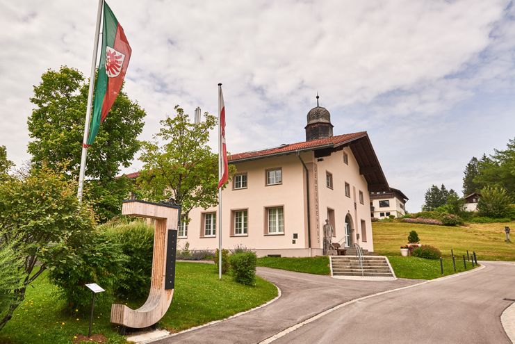
At different points in the village the letters of the village name are placed. All points can be hiked along a circular path or reached by bike. In the production of the individual letters different materials were used, depending on the artist's style. At each art object you will also find a short description for interpretation.
The trail starts at the parking lot of the Jungholz tourist office. There you will already find the first letter of the village name. Depending on the speed and length of stay at the individual letters, approx. 2 - 3 hours must be planned. Those who need a short refreshment can make a detour to one of the restaurants along the way. The circular path leads past herb gardens, a well-kept miniature golf course and the Jungholz rock bath.
Anfahrt
On the motorway A7 at the exit "Oy-Mittelberg" on the B310 direction Wertach and turn left to Jungholz.Parken
Lift parking Jungholz - free of chargeÖffentliche Verkehrsmittel
By train to Sonthofen, Pfronten/Ried or Reutte, further by bus to the Tannheimer Tal and via Oberjoch to Jungholz.
Summer hiking:
No special safety instructions to be observed. Possibly use sun or rain protection and take something to drink with you.
Winter hiking:
It should be noted that there is an increased risk of accidents and injuries during winter hiking. Especially in winter, special attention must be paid to the condition of the paths. Suitable clothing, good footwear and possibly hiking sticks provide additional safety.
Good footwear is essential despite good road conditions. The path is both asphalted and gravelled and runs partly along the main road with little traffic.
Ähnliche Touren
- Wandertour
Alp hike Söllereck - Riezlern
© Kleinwalsertal Tourismus eGen
Söllereckbahn - Alpe Schrattenwang - Mittelalp - Bergstüble - Westeggtobel - Riezlern.
mehr dazuDistanz 5,6 km Dauer 2:25 h Aufstieg 51 m Schwierigkeit leicht - Wandertour
Around the lake Schwansee (swan lake) in the Schwansee park
hike around the lake Schwansee
duration: 1 hour
length: 2 kilometers
mehr dazuDistanz 3,2 km Dauer 1:30 h Aufstieg 29 m Schwierigkeit leicht - Wandertour
Bridge building river Leiblach: Hiking along the border river - Waterway no.30 in the Western Allgaeu
© Thomas Gretler
Tour no.30 of the waterways in the Western Allgaeu invites you to a cross-border expedition into the valley of the river Leiblach. According to the motto "bridge building".
mehr dazuDistanz 11,5 km Dauer 3:50 h Aufstieg 207 m Schwierigkeit leicht - Wandertour
Bridge building river Leiblach: Hiking along the border river - Waterways in the Western Allgaeu
© Thomas Gretler
Three tours of the waterways of the Western Allgaeu (29,30 and 31) invite you to a cross-border discovery journey to the valley of the Leiblach. According to the motto 'building bridges'. The valley's lifeline is the river Leiblach, a near-natural river of the low...
mehr dazuDistanz 7,6 km Dauer 2:00 h Aufstieg 99 m Schwierigkeit leicht - Wandertour
Golfplatztour – Rundwanderung durch die Hörnerdörfer
Golfplatztour – Rundwanderung durch die Hörnerdörfer
mehr dazuDistanz 11,3 km Dauer 3:04 h Aufstieg 168 m Schwierigkeit leicht - Wandertour
Hike from Ofterschwang to Wittelsbacher Höhe
A varied circular route from Ofterschwang to the Wittelsbacher Höhe near Schweineberg over meadows and through forests and with fantastic views.
mehr dazuDistanz 6,1 km Dauer 2:00 h Aufstieg 127 m Schwierigkeit leicht - Wandertour
Moosrundweg - walk around the Tiefenberger bog near Ofterschwang
Family-friendly circular route through the ancient and idyllic bog.
mehr dazuDistanz 6,7 km Dauer 2:00 h Aufstieg 63 m Schwierigkeit leicht - Wandertour
Nature Trail - Ofterschwang
With information signs and stations on the natural development and cultivation of the cultural landscape.
mehr dazuDistanz 6,2 km Dauer 2:00 h Aufstieg 153 m Schwierigkeit leicht - Wandertour
Oberreute: Upper "Hausbachklamm"
Oberreute: Upper "Hausbachklamm"
mehr dazuDistanz 4,4 km Dauer 1:15 h Aufstieg 52 m Schwierigkeit leicht - Wandertour
Ofterschwanger Horn - a comfortable walk round the peak
A nice and easy walk with great views of the Alps at Oberstdorf.
(suiteable for prams)
mehr dazuDistanz 2,4 km Dauer 1:00 h Aufstieg 70 m Schwierigkeit leicht


Die Inhalte dieser Seite werden in Kooperation mit Outdooractive bereitgestellt.