Let yourself be inspired. Eleven stations provide information about the diverse nature, the unique mountain world and our animal kingdom. Sign in, in the largest summit book of the Alps.
- Strecke1,36 km
- Dauer1:10 h
- Aufstieg62 Hm
- Abstieg62 Hm
- Schwierigkeitleicht
Höhenprofil
Twice a week free guided tour around the Neunerköpfle, explanation of the stations and entry in the "biggest summit book of the Alps" with the experienced ski and mountain guide Klaus. Meeting point at the Neunerköpfle mountain station.
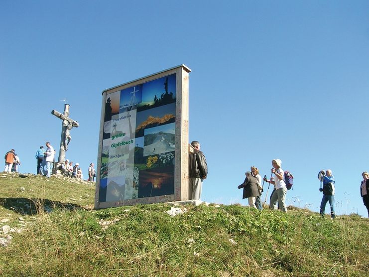
The "Largest summit book of the Alps
Hikers can immortalise themselves in the Tannheimer Tal in the largest summit book of the Alps. The largest summit book of the Alps is 3 m high and comprises two pages of 2.3 m width each. This uniqueness can be admired on the Neunerköpfle in "probably the most beautiful high valley in Europe". You will learn general information about the creation of the summit books, you will read the funniest summit book sayings, create and write your own saying and thereby immortalize yourself.
Enjoy the unique and fantastic view over the Tannheimer Tal and experience an unforgettable view of the Alps with good visibility, combined with a happy feeling of inner peace and calmness.
The trail starts at the top station of the 8-person Neunerköpfle gondola lift in Tannheim. Depending on speed and the time spent at the stations, approx. 1 - 1.5 hours must be planned. If you still have some puff left, make a short detour to the summit of Neunerköpfles: There, summer and winter the entry into the largest summit book of the Alps is waiting for you.
The trail can be hiked daily in all weathers. The trail is also well maintained in winter.
Anfahrt
On the motorway A7 at the exit "Oy-Mittelberg" on the B310 towards Wertach and to Oberjoch. There follow the signposting "Tannheimer Tal" B199, exit Tannheim, Neunerköpfle mountain railway.From the Tyrolean side via Reutte on the B198 towards Lechtal to Weißenbach, over the Gaichtpass along the B199 to the exit Tannheim, Neunerköpfle Bergbahn.Parken
At the valley station of the Neunerköpfle cable car - with costsÖffentliche Verkehrsmittel
By train to Sonthofen, Pfronten/Ried or Reutte, then by bus to Tannheim.
The theme path is relatively easy to walk and, where necessary, well secured. The whole path is covered with gravel, in steeper passages caution is advised. In winter the path is cleared of snow and also split, but good footwear is urgently required. Always walk the path with the necessary caution.
Good footwear is essential despite good road conditions
Ähnliche Touren
- Wandertour
Alp hike Söllereck - Riezlern
© Kleinwalsertal Tourismus eGen
Söllereckbahn - Alpe Schrattenwang - Mittelalp - Bergstüble - Westeggtobel - Riezlern.
mehr dazuDistanz 5,6 km Dauer 2:25 h Aufstieg 51 m Schwierigkeit leicht - Wandertour
Around the lake Schwansee (swan lake) in the Schwansee park
hike around the lake Schwansee
duration: 1 hour
length: 2 kilometers
mehr dazuDistanz 3,2 km Dauer 1:30 h Aufstieg 29 m Schwierigkeit leicht - Wandertour
Bridge building river Leiblach: Hiking along the border river - Waterway no.30 in the Western Allgaeu
© Thomas Gretler
Tour no.30 of the waterways in the Western Allgaeu invites you to a cross-border expedition into the valley of the river Leiblach. According to the motto "bridge building".
mehr dazuDistanz 11,5 km Dauer 3:50 h Aufstieg 207 m Schwierigkeit leicht - Wandertour
Bridge building river Leiblach: Hiking along the border river - Waterways in the Western Allgaeu
© Thomas Gretler
Three tours of the waterways of the Western Allgaeu (29,30 and 31) invite you to a cross-border discovery journey to the valley of the Leiblach. According to the motto 'building bridges'. The valley's lifeline is the river Leiblach, a near-natural river of the low...
mehr dazuDistanz 7,6 km Dauer 2:00 h Aufstieg 99 m Schwierigkeit leicht - Wandertour
Golfplatztour – Rundwanderung durch die Hörnerdörfer
Golfplatztour – Rundwanderung durch die Hörnerdörfer
mehr dazuDistanz 11,3 km Dauer 3:04 h Aufstieg 168 m Schwierigkeit leicht - Wandertour
Hike from Ofterschwang to Wittelsbacher Höhe
A varied circular route from Ofterschwang to the Wittelsbacher Höhe near Schweineberg over meadows and through forests and with fantastic views.
mehr dazuDistanz 6,1 km Dauer 2:00 h Aufstieg 127 m Schwierigkeit leicht - Wandertour
Moosrundweg - walk around the Tiefenberger bog near Ofterschwang
Family-friendly circular route through the ancient and idyllic bog.
mehr dazuDistanz 6,7 km Dauer 2:00 h Aufstieg 63 m Schwierigkeit leicht - Wandertour
Nature Trail - Ofterschwang
With information signs and stations on the natural development and cultivation of the cultural landscape.
mehr dazuDistanz 6,2 km Dauer 2:00 h Aufstieg 153 m Schwierigkeit leicht - Wandertour
Oberreute: Upper "Hausbachklamm"
Oberreute: Upper "Hausbachklamm"
mehr dazuDistanz 4,4 km Dauer 1:15 h Aufstieg 52 m Schwierigkeit leicht - Wandertour
Ofterschwanger Horn - a comfortable walk round the peak
A nice and easy walk with great views of the Alps at Oberstdorf.
(suiteable for prams)
mehr dazuDistanz 2,4 km Dauer 1:00 h Aufstieg 70 m Schwierigkeit leicht


Die Inhalte dieser Seite werden in Kooperation mit Outdooractive bereitgestellt.