This round tour leads you to the six most beautiful view points of Lindau's Lake Constance area, passing orchards, vine and picturesque villages.
Landratsamt Lindau (Bodensee)
- Strecke25,66 km
- Dauer3:00 h
- Aufstieg284 Hm
- Abstieg284 Hm
- Schwierigkeitmittel
Höhenprofil
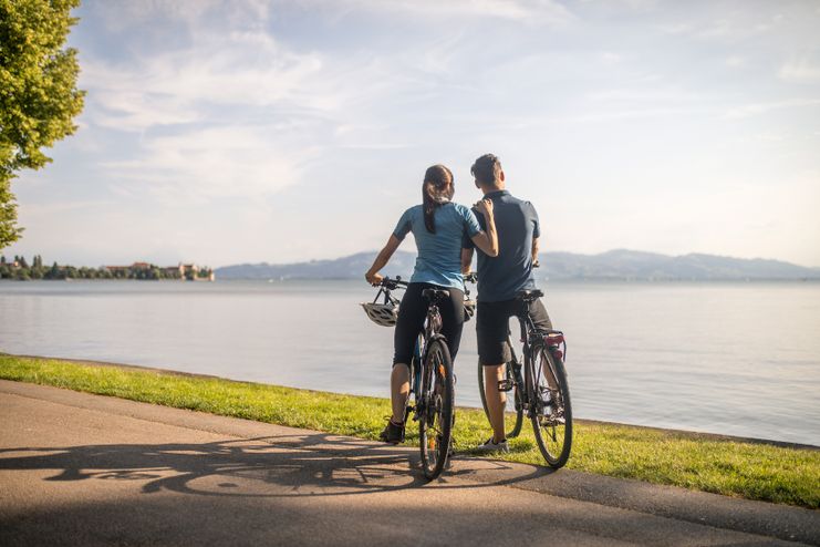
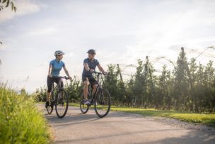
In front of the railway station on the island of Lindau we get on our bikes and leave the historical center on the railway embankment. The marking no.1 escorts us on this tour. On the mainland we turn left and pass the tracks. Now we are on the way to the first viewpoint 'Lotzbeckpark' near the lakeside in Bad Schachen: enjoy the atmosphere at the lakeside and relax on the comfortable double wooden loungers. Just imagine the numerous villas that have once been in this park and let the moment and the impressive panoramic view work its magic.
Enough relaxation - we get back in the saddle and drive unhurriedly to the next viewpoint 'Giebelbach': from the viewpoint we have a clear view of the 'Pulverturm' on the island of Lindau. Fridolin, the night watchman, tells us more about th history and the importance of the tower in a video (use the QR-code on the panel to watch the video).
Let's leave the beautiful promenade of Lindau and head towards Wasserburg. To our left side, there is the 'Lindenhofpark' where many visitors enjoy the sunshine on warm days. Passing the small village Reutenen we approach Wasserburg. We pass through the quiet village and cycle through a nature reserve. We look back to the attractive peninsula with the St. George's church. Our next destination is Nonnenhorn. We reach the town on the Wasserburger Straße. Before we get to the town center, we are drawn towards the water. We watch out for the signs of the panoramic cycle tour leading us to the viewpoint 'Im Paradies' (passing the municipal fish hatchery). Here we can take a marvellous look at the Lake and the Wasserburg peninsula.
The idyllic wine village encourages to linger and to enjoy. Passing the old 'Weintorkel' we can relax and regain our strength over a sundae or a 'small refreshment'. Afterwards we see the St. James' chapel before we carry on to Hege and Selmnau.
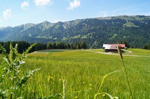
After our arrival at Selmnau we cycle uphill on a path to the viewpoint 'Antoniuskapelle'. The effort was worth it because we can enjoy an unforgettable view over the expanses of Lake Constance and the slopes full of vine and fruit. We learn more about the winemaking in a video (use the QR-code and watch with your mobile device). The panorama table on the viewing platform indicates mountains and countries around Lake Constance.
Along orchards, the signage leads us on well-developed paths via Hengnau and Rickatshofen. In a pleasant up and down course we soon get to Unterreitnau. Next to the church we turn right and reach the road. Here we turn right, pass under the main road. After the underpass, we sharply turn right towards Taubenberg which we reach in the ascent. There we can regain our strengt in a restaurant before we head downhill to Bodolz. Before we reach Bodolz, the signage leads us to a hidden viewpoint 'Herrmannsberg'. After the exhausting ascent we rest on the double wooden lounger and secretly let the impressive panorama do its magic. Have you ever heard of the apple princess? We get to know her in a video (use the QR-code on the panel). She tells us about the role the apple plays for the region and where to buy fine fruit brandy as a souvenir.
We continue our tour and cross the railway line in order to get to Schönau. The signage leads us to the last viewpoint called 'Entenberg': After having climbed the numerous steps a free view of the island of Lindau opens to us. In the video, we learn more about the characteristics and pitfalls of the four countries surrounding Lake Constance. Having lasting impressions in our bags we cycle along. Soon we approach the lakeside via Aeschach. Finally, the signage leads us across the bridge to the island of Lindau. A visit of one of the numerous historic buildings and of the Lindau harbour is recommendable at the end of the tour.
Alternative starting points: Wasserburg, Nonnenhorn and Bodolz.
Ähnliche Touren
- Radtour
Biking on the the Allgaeu cheeseroad - cheese and beer
© Frederick Sams
Biking on the the Allgaeu cheeseroad - cheese and beer
mehr dazuDistanz 32,6 km Dauer 2:30 h Aufstieg 460 m Schwierigkeit mittel - Radtour
Cycling on the "Allgäuer Käsestraße" (Allgaeu cheese road) - cheese and water fun
© Kempten Tourismus
Water fun at its finest. Passing creeks and ponds, the tour leads to three dairies, producing the best Allgäu cheese. The "Burkwanger Baggersee" (Burkwang quarry pond) and the public pool in Rentershofen provide cooling occasionally and at the end of the tour. A special...
mehr dazuDistanz 42,7 km Dauer 3:22 h Aufstieg 454 m Schwierigkeit mittel - Radtour
Cycling on the "Allgäuer Käsestraße" (Allgaeu cheese road) - cheese with a view
© Dorfsennerei Böserscheidegg
Magnificent views of the Nagelfluh mountain range, Lake Constance, the Swiss mountains and the mountains of the Bregenzerwald - you will be amazed on this tour! A special treat: the tour can be combined ideally with a hiking tour on the "Josef-Rupp-Käsewanderweg"...
mehr dazuDistanz 30,7 km Dauer 2:44 h Aufstieg 558 m Schwierigkeit mittel - Radtour
Tour through the Leiblach valley
The tour through the Leiblach valley leads us from the island of Lindau to Hergensweiler. We can experience marvellous views and cross orchards and have not only the opportunity to set in, but also to swim.
mehr dazuDistanz 24,3 km Dauer 3:30 h Aufstieg 262 m Schwierigkeit mittel - Mountainbike
Ofterschwang cycle tour Forest-Meadows-Mountain
Difficult but varied tour through forests, crossing meadows and over the mountain-back of the Ofterschwanger Horn.
mehr dazuDistanz 14,8 km Dauer 2:00 h Aufstieg 556 m Schwierigkeit mittel
Die Inhalte dieser Seite werden in Kooperation mit Outdooractive bereitgestellt.