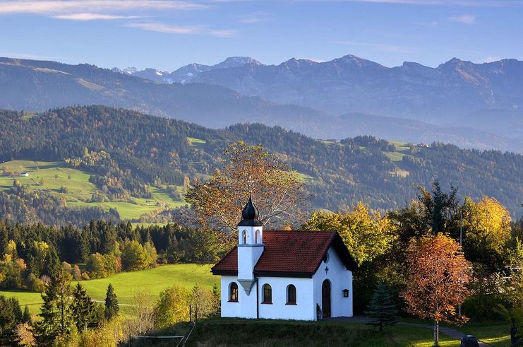
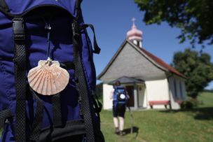
There are 13 chapels surrounding the spa resort Scheidegg, one of them ecumenical. All of them are great treasures. The grand ecumenical chapel path links ten of these chapels that are worth seeing on an expanded hiking tour.
- Strecke22,36 km
- Dauer7:00 h
- Aufstieg632 Hm
- Abstieg632 Hm
- Schwierigkeitschwer
Höhenprofil
In ancient times the people went from spring to spring in order to find pastures and resting places for their cattle. Later on, chapels were built at the springs. So one could go from spring to spring and from chapel to chapel.
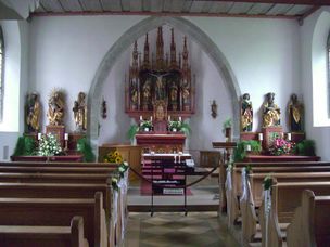
We start at the spa house and walk through meadows on a footpath until we come across a mountain road. We turn right and follow the mountain road until leads to the Zollstraße. Bearing left, we come to first chapel on our tour, a memorial chapel for soldiers. We go back on the Zollstraße and turn left into the road Sonnenstraße. In the road Alemannweg we bear left twice and follow the hiking trail round Scheidegg for some time. The road we come across takes us to the village Bieslings to the left. There we can visit the chapel of St.Gall-and-Magnus. Back at the village entrance of Bieslings we turn right to the waterfalls of Scheidegg. We bear right at the road and hike to the village Ostkinberg. After crossing the road B308 we come across the first houses of Ostkinberg. Behind these houses, a path leads to the edge of the forest. There, we first go right then left, pass the small village Loerz and come across the chapel of St.Wendelin to our left. After this short side trip, we turn left in Loerz and get to the village Haus am Wald with its Lady Chapel. Behind the chapel we hike through the fields and reach the village Böserscheidegg with its via the villages Roederbuehl and Buflingsried with its chapel of St. Catherine-and-Anthony. Infront of the chapel we turn left, crossing fields and reach Schalkensried, where the chapel of St.Martina, our next stage goal, awaits us. Behind the village Albers a pathway goes right, leading us via the village Bärfällen to the village Brand. Even before we come across the first we turn left and come to a larger road and cross it. We now have "Forst" to our right. There, we can find another chapel,the ecumenical chapel of St. Hubert. The way leas us straight ahead crossing the village Bronschwand and the mill Häuslingsmühle to the village Unterstein with its chapel of St.Anna-and-Joachim. The next chapel is situated between Oberstein and Moeggers, shortly behind the Austrian boarder. we reach it by walking a pathway to the right behind Unterstein to Oberstein. Having reached Oberstein we first hike rightwards and then leftwards into the woods. After we visited the chapel of St. Ulrich we hike a little while back to and reach a fork. There we walk leftwards towards Gaisgau. From Gaisgau we turn right and walk back to the spa house via Ebenschwand with its Sacred Heart Chapel.
Ähnliche Touren
- Wandertour
"Himmelstürmer"-Trail
© Allgäu GmbH
The "Himmelsstürmer"-Route consists of 24 stage (not counting access routes) and is 342 km long.
mehr dazuDistanz 432,5 km Dauer 148:35 h Aufstieg 17.980 m Schwierigkeit schwer - Wandertour
"Wasserläufer"-Trail
© Allgäu GmbH
The "Wasserläufer"-Route consists of 26 stages (not counting access routes) and is 384 km long.
mehr dazuDistanz 381,6 km Dauer 110:10 h Aufstieg 11.237 m Schwierigkeit schwer - Wandertour
Bridge building river Leiblach: Hiking along the border river - Waterway no.31 in the Western Allgaeu
Three tours of the waterways of the Western Allgaeu (29,30 and 31) invite you to a cross-border discovery journey to the valley of the Leiblach. According to the motto 'building bridges'. The valley's lifeline is the river Leiblach, a near-natural river of the low...
mehr dazuDistanz 21,5 km Dauer 6:20 h Aufstieg 539 m Schwierigkeit schwer - Wandertour
Camino de Santiago from Missen to Lindau, respectively Nonnenhorn (main route)
Going on a pilgrimage between the Allgaeu and the Lake ConstanceThe Camino de Santiago in the district of Lindau is part of the Munich, respectively the Augsburg Camino de Santiago.You're accompanied by neat chapels, lush green meadows in the pre-alpine landscape of the...
mehr dazuDistanz 64,6 km Dauer 17:20 h Aufstieg 758 m Schwierigkeit schwer - Wandertour
Camino de Santiago from Missen via Lindenberg to Lindau, respectively Nonnenhorn (variant)
A pilgrimage walk between the Allgaeu and the Lake ConstanceThe Camino de Santiago leading through the district of Lindau is part of Camino de Santiago of Munich respectively Augsburg. You will be accompanied by neat chapels, rich green meadows in the pre-alpine...
mehr dazuDistanz 63,6 km Dauer 17:50 h Aufstieg 658 m Schwierigkeit schwer - Wandertour
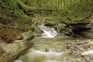
Creeks, ravines, moors - waterway 9 in the western Allgaeu - entry Oberreute
© Thomas Gretler
Roaring mountain streams and deep ravines, green meadows and idyllic moors, fertile forests and picturesque villages - on this demanding cross-border one-day-hike (tour 9) you can explore the whole diversity of the western Allgaeu and the Bregenz forest.
mehr dazuDistanz 23,6 km Dauer 7:30 h Aufstieg 631 m Schwierigkeit schwer - Wandertour
From Haldensee to Litnisschrofen
© Tannheimer Tal
Down from the valley the Litnisschrofen (2068m) is almost not visible. Seen from surrounding peaks such as the Krinnespitze or the Neunerköpfle, the isolated standing one with its distinctive Schrofen wall catches the eye.
mehr dazuDistanz 10,4 km Dauer 4:30 h Aufstieg 938 m Schwierigkeit schwer - Wandertour
rway 9 in the westCreeks, ravines, moors - via The "Hausbachklamm to the Wildrosenmoos - Westallgaeu waterways 9
© Thomas Gretler
Rushing mountain creeks and deep canyons, green meadows and idyllic moors, splendid forests and picturesque villages -on this demanding cross-border one-day-hike you can explore the whole diversity of the landscape of the Western Allgaeu and the Bregenzerwald. If you...
mehr dazuDistanz 20,3 km Dauer 7:30 h Aufstieg 479 m Schwierigkeit schwer
Die Inhalte dieser Seite werden in Kooperation mit Outdooractive bereitgestellt.