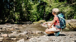
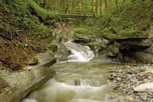
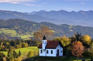
Roaring mountain streams and deep ravines, green meadows and idyllic moors, fertile forests and picturesque villages - on this demanding cross-border one-day-hike (tour 9) you can explore the whole diversity of the western Allgaeu and the Bregenz forest.
Thomas Gretler
- Strecke23,61 km
- Dauer7:30 h
- Aufstieg631 Hm
- Abstieg631 Hm
- Schwierigkeitschwer
Höhenprofil
Starting at the village square of Oberreute along the main street towards Sulzberg, we hike until we come across a riding school to our right. Shortly before we reach the riding school, we turn left and cross a meadow towards the "Obere Hausbachklamm" (Upper Hausbach ravine). We follow the signpost "Obere Hausbachklamm" and get into the forest after some time. We hike along the ravine upstream and follow the pathway up to the headwaters and further on into the romantic "Wildrosenmoos" (moss of wild roses).
In the "Wildrosenmoos", a landscape consisting of moors and marshes, the big swamp pond invites us to take a rest . The waters of the abandoned peat-ditch reflect downy birches and mountain pines. The plants in these habitats are very vulnerable. That is why you must not leave the trail here. A small shack at the wayside reminds you of the times when peat was extracted: Some devices, formerly used for peat extraction, are shown in the shack. The pathway leads us from the "Wildrosenmoos", maybe after a little side trip to the "Kalter Brunnen" (cold well), to the Austrian municipality Sulzberg. When you split the circular hike into two stages, you have enough time for a short side trip to the "Kalter Brunnen". The hiking trail leads us from the "Wildrosenmoos" to the "Hochsträß", with 1041 metres in heigjht the highest point of the elongated "Sulzberger Rücken" (Sulzberg Ridge). Here stands an old house that was used by frontiersmen as a reminder of the times when the German-Austrian border was more controlled by customs officers. We continue our way to the source are "Kalter Brunnen". Here, a wooden well and a beautiful resting place with a small shelter, including table and benches are waitng for us. The hiking trail continues to the Austrian municipality Sulzberg that is located at an altitude of 1015 metres.
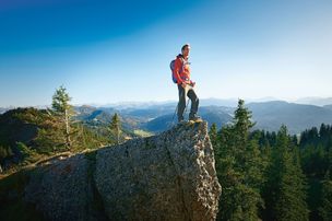
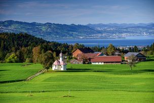
Descending from sulzberg, we can repeatedly enjoy fantastic views of the Rothach valley, the Rhine valley behind and the mountains of the "Pfänderstock" and the massif of the Saentis. The circular route starts in the village Thal and leads us via the villages Eyenbach and Salmers with its nice "Augenkapelle" to the river Rothach. We cross the river on a bridge, coming to the old well house in the village Siebers. The well in Bad Siebers is one of the oldest bathing and minerals springs in the Allgaeu region. It is documented until far into the middle Ages. Severeal metres further, you can see the new well house of the spring Siebers-Quelle. In this well house, 60 litres of pure natural mineral water are extracted per minute. Along the Rothach river, the trail leads us through a floodplain forest that is rich in species, to the village Bremenried.
The barbecue area right on the riverbank is a perfect place to rest. We pass the sewage plant of the waste water association "Rothach" that has to deliever a particularly high cleaning performance like all sewage plants in the catchment area of the Lake Constance. Where the streams Rothach and the Hausbach meet, a small power station that has to produce energy, is located. A way alongside the Hausbach leads us to Weiler.
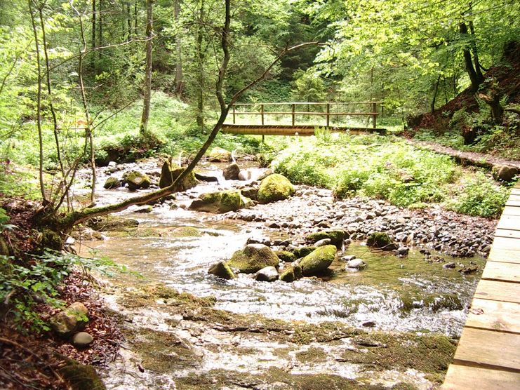
The entry of the ravine Hausbachklamm begins at the parish church of Weiler. Only few metres further, you come across the Lourdes grotto built in 1890 and enters a shady canyon forest. Passing small waterfalls and weirs, the trail leads us past a blocking debris. It is a reminder that the Hausbach, with its gradient of seven per cent, on average, can become a roaring mountain torrent at high watermark . Also on hot summer days. The section at the bridge Kapfmühlenbrücke is especially beautiful: here, the Hausbach makes his way through a bottleneck that's milled deeply into the sandstone. The pathway leads steeply uphill to the impressive mountain ridge "Hohe Wand" ("High Wall"). We cross the creek on a bridge and can see a second blocking debris. The steep lopes with its dripping moss cushions and the Hausbach, rushing into the valley in deep channels.
On the bridge called "Tobelbachbrücke" we hike uphill until we reach the bridge called "Trogener Brücke". Directly above the bridge there is a beautiful resting place for families with children: at the barbecue area the children can rampage and play in the shallow and gravelly streambed. Now, the path is not so steep anymore. A little bit upstream there is a Wendy house and a rope slide crossing the Hausbach stream for adventurous children. Having passed the playground we follow the path upstream for a little while and then we are heading back to Oberreute following the signposts.
Course: Village square Oberreute - Upper ravine of the Hausbach ("Obere Hausbachklamm") - Schnellers - Headwaters - Wildrosenmoos (side trip: "Kalter Brunnen") - Sulzberg - Thal - Eyenbach - Salmers - Bad Siebers - Bremenried - church square Weiler - Lourdes grotto - Lower Hausbachklamm - Upper Hausbachklamm - Oberreute/village square
You will definitely need sturdy shoes in the ravine of the Hausbach.
Ähnliche Touren
- Wandertour
"Himmelstürmer"-Trail
© Allgäu GmbH
The "Himmelsstürmer"-Route consists of 24 stage (not counting access routes) and is 342 km long.
mehr dazuDistanz 432,5 km Dauer 148:35 h Aufstieg 17.980 m Schwierigkeit schwer - Wandertour
"Wasserläufer"-Trail
© Allgäu GmbH
The "Wasserläufer"-Route consists of 26 stages (not counting access routes) and is 384 km long.
mehr dazuDistanz 381,6 km Dauer 110:10 h Aufstieg 11.237 m Schwierigkeit schwer - Wandertour
Bridge building river Leiblach: Hiking along the border river - Waterway no.31 in the Western Allgaeu
Three tours of the waterways of the Western Allgaeu (29,30 and 31) invite you to a cross-border discovery journey to the valley of the Leiblach. According to the motto 'building bridges'. The valley's lifeline is the river Leiblach, a near-natural river of the low...
mehr dazuDistanz 21,5 km Dauer 6:20 h Aufstieg 539 m Schwierigkeit schwer - Wandertour
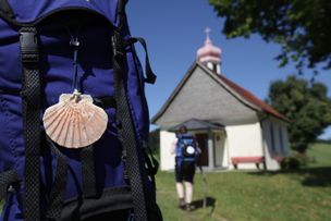
Camino de Santiago from Missen to Lindau, respectively Nonnenhorn (main route)
Going on a pilgrimage between the Allgaeu and the Lake ConstanceThe Camino de Santiago in the district of Lindau is part of the Munich, respectively the Augsburg Camino de Santiago.You're accompanied by neat chapels, lush green meadows in the pre-alpine landscape of the...
mehr dazuDistanz 64,6 km Dauer 17:20 h Aufstieg 758 m Schwierigkeit schwer - Wandertour
Camino de Santiago from Missen via Lindenberg to Lindau, respectively Nonnenhorn (variant)
A pilgrimage walk between the Allgaeu and the Lake ConstanceThe Camino de Santiago leading through the district of Lindau is part of Camino de Santiago of Munich respectively Augsburg. You will be accompanied by neat chapels, rich green meadows in the pre-alpine...
mehr dazuDistanz 63,6 km Dauer 17:50 h Aufstieg 658 m Schwierigkeit schwer - Wandertour
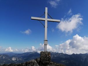
From Haldensee to Litnisschrofen
© Tannheimer Tal
Down from the valley the Litnisschrofen (2068m) is almost not visible. Seen from surrounding peaks such as the Krinnespitze or the Neunerköpfle, the isolated standing one with its distinctive Schrofen wall catches the eye.
mehr dazuDistanz 10,4 km Dauer 4:30 h Aufstieg 938 m Schwierigkeit schwer - Wandertour
rway 9 in the westCreeks, ravines, moors - via The "Hausbachklamm to the Wildrosenmoos - Westallgaeu waterways 9
© Thomas Gretler
Rushing mountain creeks and deep canyons, green meadows and idyllic moors, splendid forests and picturesque villages -on this demanding cross-border one-day-hike you can explore the whole diversity of the landscape of the Western Allgaeu and the Bregenzerwald. If you...
mehr dazuDistanz 20,3 km Dauer 7:30 h Aufstieg 479 m Schwierigkeit schwer - Wandertour
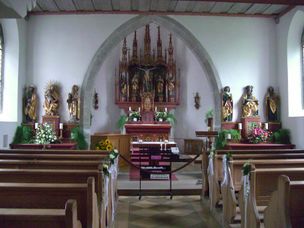
Scheidegg R1 Grand ecumenical chapel path
There are 13 chapels surrounding the spa resort Scheidegg, one of them ecumenical. All of them are great treasures. The grand ecumenical chapel path links ten of these chapels that are worth seeing on an expanded hiking tour.
mehr dazuDistanz 22,4 km Dauer 7:00 h Aufstieg 632 m Schwierigkeit schwer
Die Inhalte dieser Seite werden in Kooperation mit Outdooractive bereitgestellt.