This trail leads around the Neunerköpfle and provides information about nature, mountains and animals in the Tannheimer Tal. .
- Strecke2,22 km
- Aufstieg69 Hm
- Abstieg69 Hm
- Schwierigkeitleicht
Höhenprofil
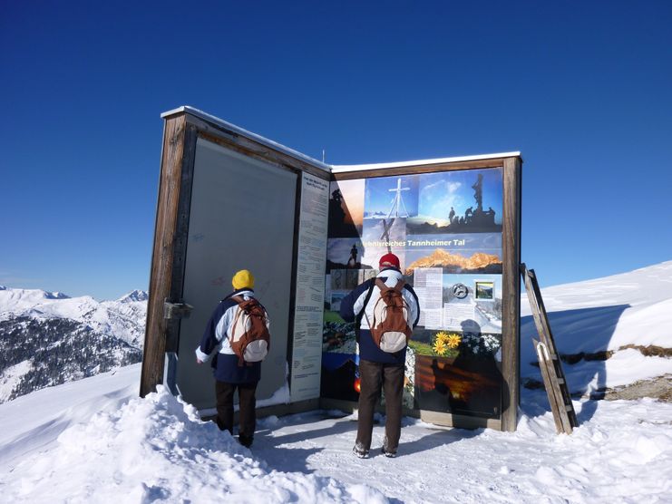
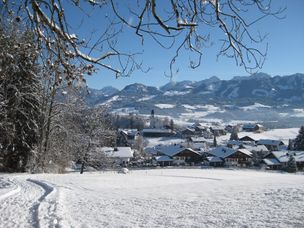
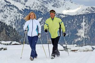
The hike on and up the Neunerköpfle in Tannheim is suitable for families and starts at the top station of the cable car. The winter hiking trail is cleared daily and leads to the summit of Neunerköpfle. There is also the largest summit book of the Alps (2 pages á 3x 2,3m) in which you can also sign in. The marvellous view over the whole Tannheimer Tal remains also on the approx. 2.2 km long new hiking trail at almost 1900 metres above sea level
From the top station of the 8-person Neunerköpfle gondola lift in Tannheim, the path first leads up a short distance at the edge of the ski slope. The path continues to the right to the paraglider launch site. It is an unforgettable experience to watch the pilots at the start. Now the path goes slightly downhill. In front of us an impressive winter landscape with the snow-covered peaks of the Geißhorn, Rauhorn and Kugelhorn. On the left below us, the village of Tannheim is idyllically situated. After a short ascent we reach a saddle. To the left we see the Usseralpe and to the right below the Strindenalpe. The turning point of the winter hiking trail is now reached. On the higher return path we can already see the summit of Neunerköpfles in front of us. Shortly below the summit is also the largest summit book of the Alps, which measures 3 metres in height and 2 pages, each 2.3 metres wide. Beside the overwhelming view over the whole valley, an almost boundless far view, also the summit cross with a wooden body is especially worth seeing. Bergdohlen above us and the skiers on the slopes below us make your heart beat a little faster. The descent to the top station is on the flank of the Neunerköpfles, partly with railings on the valley side, and gives us another chance to see the Tannheimer Tal from above. Should we get hungry or thirsty before the descent with the gondola, a refreshment at this altitude is also provided.
Anfahrt
On the motorway A7 at the exit "Oy-Mittelberg" on the B310 towards Wertach and to Oberjoch. There follow the signposting "Tannheimer Tal" B199, exit Tannheim, Neunerköpfle mountain railway.From the Tyrolean side via Reutte on the B198 towards Lechtal to Weißenbach, over the Gaichtpass along the B199 to the exit Tannheim, Neunerköpfle Bergbahn.Parken
At the valley station of the Neunerköpfle cable car - chargeable.Öffentliche Verkehrsmittel
By train to Sonthofen, Pfronten/Ried or Reutte, then by bus to Tannheim.
The theme path is relatively easy to walk and, where necessary, well secured. The whole path is covered with gravel, in steeper passages caution is advised. In winter the path is cleared of snow and also split, but good footwear is urgently required. Always walk the path with the necessary caution.
Good footwear is essential as the ground is hard snow.
Ähnliche Touren
- Winterwandern
Short Hochwiesweg trail - Winter hike in Ofterschwang
A small walk with only a slight ascent and a wonderful view of Ofterschwang.
mehr dazuDistanz 1,8 km Dauer 0:40 h Aufstieg 72 m Schwierigkeit leicht - Winterwandern
Sonnenplateau winter hike between Ofterschwang and Untermühlegg
Wonderful round tour through fairytale landscapes in the Oberallgäu between Bolsterlang and Ofterschwang. Fantastic view of the Allgäu main ridge.
mehr dazuDistanz 4,8 km Dauer 1:30 h Aufstieg 30 m Schwierigkeit leicht - Winterwandern
Winter walk around the Ofterschwanghorn
A nice and easy walk around the Ofterschwanger Horn (mountaintop) with great views of the Allgäu Alps.
mehr dazuDistanz 2,4 km Dauer 1:15 h Aufstieg 80 m Schwierigkeit leicht - Winterwandern
Winterspaziergang - Beste Aussichten zwischen Untermühlegg und Muderbolz
Winterspaziergang - Beste Aussichten zwischen Untermühlegg und Muderbolz
mehr dazuDistanz 5,4 km Dauer 1:20 h Aufstieg 88 m Schwierigkeit leicht - Winterwandern
Winterwandern Hochwiesweg Runde - Ofterschwang
A pleasant round trip with only a slight ascent and a magnificent view over Ofterschwang, the Iller Valley and the Allgäu Alps.
mehr dazuDistanz 3,6 km Dauer 1:15 h Aufstieg 93 m Schwierigkeit leicht
Die Inhalte dieser Seite werden in Kooperation mit Outdooractive bereitgestellt.