The Bikeschule Alpstern is looking forward to opening the "MÜHLWALDTRAILS" from May 2020.
- Aufstieg3 Hm
- Abstieg7 Hm
- Schwierigkeitleicht
Höhenprofil
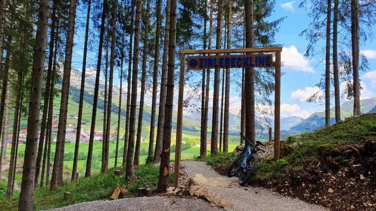
The 3 practice runs of 500m each offer different downhill runs with different demands: The flowing PONTENLINE winds its way through the Mühlwald with numerous curves and waves. The CIRLESECKLINE and ROHNENELINE are technically more demanding with roots and heels. All 3 trails start at the same starting point and end together again at the end. So beginners and experts can bike together.
Route number: 8023
You start at the height of the Mühlhanglift mountain station, at the starting point of the 3 MÜHLWALD-TRAILS and end at the valley station of the Mühlhanglift. The Zirleseckline is a variant to the other two lines and can be achieved by the flowing Pontenline or the technical raw line. It is characterized by a curvy uphill and downhill section and flows into the flowing Pontenline in the lower part. The subsoil is natural (forest soil and gravel). The Zirleseckline is designed exclusively for bikers.
Anfahrt
On the motorway A7 at the exit "Oy-Mittelberg" on the B310 towards Wertach and to Oberjoch. There follow the signposting "Tannheimer Tal" B199, exit Zöblen. From the Tyrolean side via Reutte on the B198 towards Lechtal to Weißenbach, over the Gaichtpass along the B199 to the exit Zöblen.Parken
Lift parking place Zöblen - with costsÖffentliche Verkehrsmittel
By train to Sonthofen, Pfronten/Ried or Reutte, then by bus to Zöblen.It should be noted that mountain biking may involve an increased risk of accidents and injuries. Despite careful route planning, a basic risk always remains. Tour preparation through endurance sports, appropriate technical training and further education as well as personal prudence reduces the danger of accidents and risks. But please never forget that the weather in the mountains can change very quickly. Stay on the marked paths.
Drive on the "safe side" in Tannheimertal
In Austria, mountain biking is generally prohibited by law on all forest and hiking trails, with the exception of mountain bike trails expressly approved for this purpose. The entrances on forest roads are sometimes marked with signs prohibiting driving and additional information such as "Cycling prohibited". Hiking trails do not have these prohibition signs, but nevertheless it is forbidden to use the trails.
The routes can be ridden with a normal MTB, which can also be rented in sports shops. The personal equipment must be safe and serviceable and meet the relevant technical standards. Full mountain bike equipment is highly recommended, even for experienced cyclists! Helmet required!
Ähnliche Touren
- Mountainbike
Forest and meadows cycling tour through Ofterschwang
Medium-heavy round with short, steep climbs, but also many descents to relax.
mehr dazuDistanz 12,0 km Dauer 1:20 h Aufstieg 336 m Schwierigkeit leicht
Die Inhalte dieser Seite werden in Kooperation mit Outdooractive bereitgestellt.