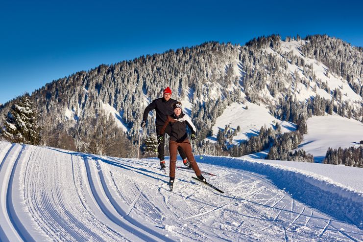
This round track Gaichtpaß promises an absolute highlight with the mountain panorama in Nesselwängle and the crossing of the frozen Haldensee.
- Strecke18,88 km
- Dauer4:00 h
- Aufstieg53 Hm
- Abstieg53 Hm
- Schwierigkeitleicht
Höhenprofil
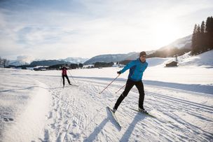
Cruise through the Tannheimer Tal on the wonderfully groomed cross-country ski run. On the route you will find several possibilities to stop and rest.
Tyrolean cross-country skiing trail seal of approval
For two decades now, the Tyrolean provincial government has been awarding the Tyrolean cross-country ski trail seal of approval under certain conditions to those who apply for it.
The Tannheimer Tal is a "cross-country skiing paradise". Not only the ADAC Ski Guide 2008 finds this and nominated the region as one of the top 10 skiing areas in the category Nordic/Cross-country skiing. There was also a special award from the Federal State of Tyrol: the "Cross-country Seal of Quality of the Federal State of Tyrol". This is valid for three years and criteria such as number of tracks, preparation, orientation or marking are regularly checked.
The Tannheimer Tal has optimal cross-country skiing conditions with a 140-kilometre-long cross-country trail network and a maximum difference in altitude of 50 metres. The trails are suitable for classic style as well as for skating and offer cross-country skiers of all skill levels the appropriate challenges.
We start at the building of the Tannheim Tourist Office and follow the easterly track across the flat meadows with a wonderful view of the Rote Flüh and the Gimpel. On the southern shore of the Haldensee we follow the trail along the edge of the forest to Nesselwängle. Below the Tannheimer Gruppe and the Krinnenspitze a wide loop is made over the outermost meadows of the valley.
The return to Tannheim takes place over the flat meadows of Nesselwängle and after an easy descent we reach the eastern shore of the Haldensee. The highlight on this circular trail is the crossing of the frozen Haldensee. The cross-country trail continues past Grän, which lies on the sunny side of the valley, and leads back to Tannheim via beautiful wide meadows with a magnificent view of the expanse of "probably the most beautiful high valley in Europe".
Anfahrt
On the motorway A7 at the exit "Oy-Mittelberg" on the B310 towards Wertach and to Oberjoch. There follow the signposting "Tannheimer Tal" B199, exit Tannheim.From the Tyrolean side via Reutte on the B198 towards Lechtal until Weißenbach, over the Gaichtpass along the B199 until exit Tannheim.Parken
Lift parking place in Tannheim - with costsÖffentliche Verkehrsmittel
By train to Sonthofen, Pfronten/Ried or Reutte, then by bus to TannheimObserve the FIS rules of conduct for cross-country skiers!
A secure control of the sports equipment even in bad snow conditions and good physical condition are basic requirements for cross-country skiing.Choosing the right speed - adapted to the skier's ability and degree of fatigue - greatly reduces the risk of accidents and injuries.
Stay on the route: All the tours described here are on groomed trails. So do not deviate from the route.
The cross-country skiing trail map of the Tannheimer Tal makes it easier for you to plan your tours, shows the distances and makes it easier to estimate the running time.
An up-to-date and well-kept/maintained equipment (skis, bindings, boots, poles and clothing) not only provides a considerable degree of safety but also makes cross-country skiing much easier. Sun protection (high protection factor and possibly sunglasses) as well as sufficient liquid should not be forgotten.
Ähnliche Touren
- Langlauf
Dorfloipe - cross-country skiing in Ofterschwang
Short, easy beginners' round on the southern outskirt of Ofterschwang with a magnificent mountain view of the Allgäu Alps. Use of the cross-country ski trail is free of charge.
mehr dazuDistanz 1,0 km Dauer 0:15 h Aufstieg 10 m Schwierigkeit leicht - Langlauf
Sonnenalp trail - cross-country skiing in Ofterschwang
Besides flat sections in Tiefenberger Moos also some climbs in beautiful Allgäuer winter landscape between Ofterschwang and Bolsterlang. Use of the Sonnenalp trail is free of charge. It offers connections to the Bolsterlang cross-country course.
mehr dazuDistanz 3,7 km Dauer 0:45 h Aufstieg 15 m Schwierigkeit leicht
Die Inhalte dieser Seite werden in Kooperation mit Outdooractive bereitgestellt.